
July 04 , 2018.
Hawai : Kilauea :
Tuesday, July 3, 2018, 11:21 AM HST (Tuesday, July 3, 2018, 21:21 UTC)
19°25’16 » N 155°17’13 » W,
Summit Elevation 4091 ft (1247 m)
Current Volcano Alert Level: WARNING
Current Aviation Color Code: ORANGE
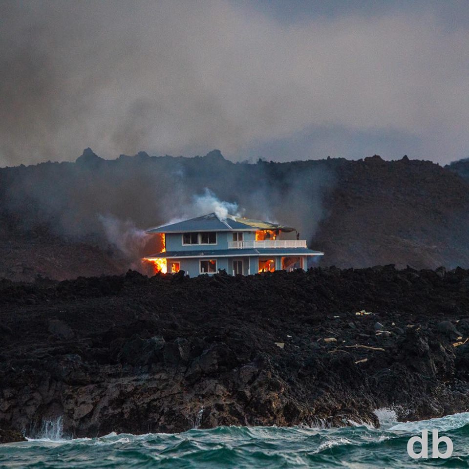
Kīlauea Volcano Lower East Rift Zone
The eruption in the lower East Rift Zone (LERZ) continues with no significant change during the past 24 hours.
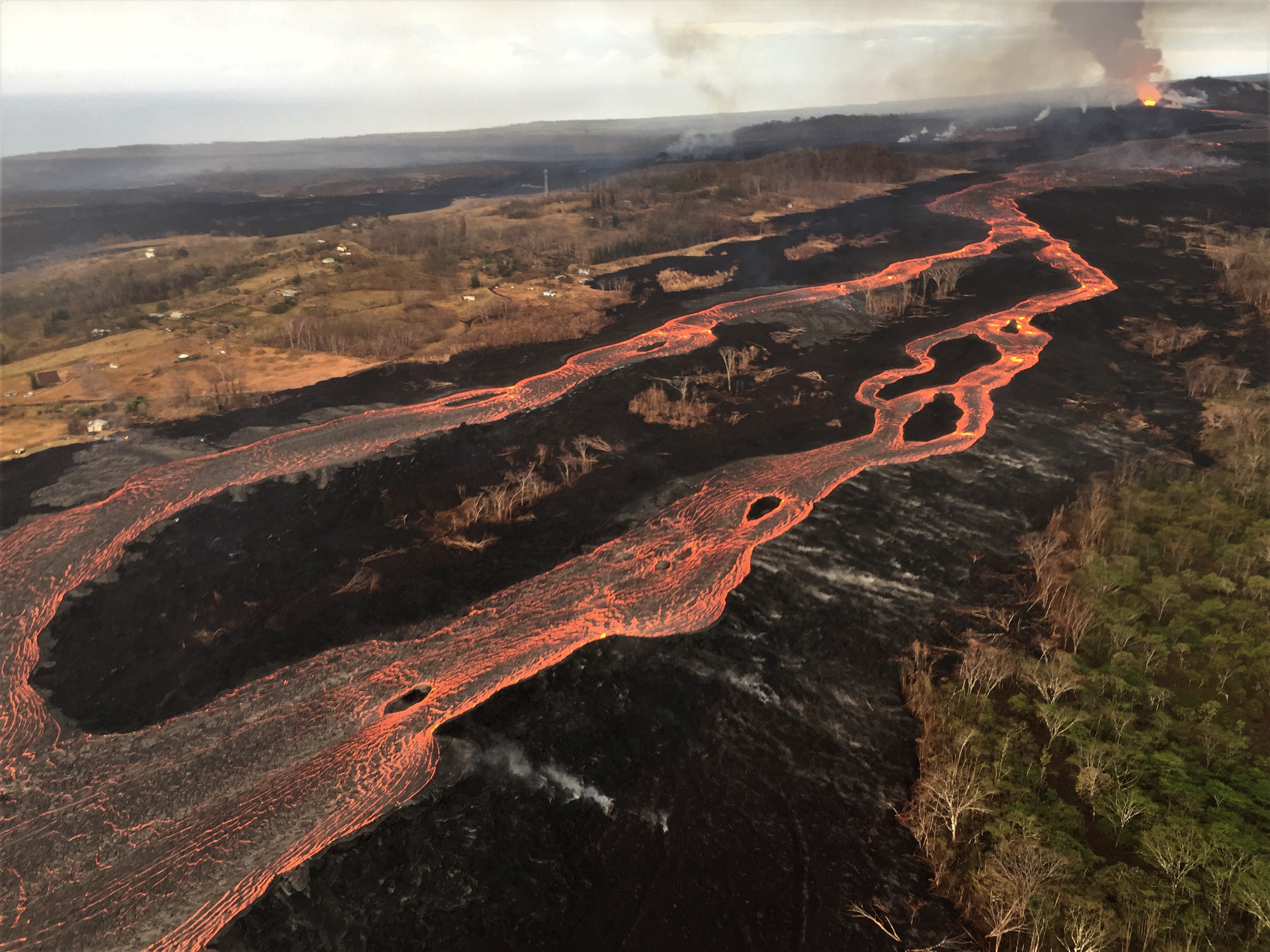
Fissure 8 fountains continue to supply lava to the open channel with small intermittent overflows of short duration. Overflows appear as lighter gray / silver areas on the channel margins. A larger active overflow can be seen in the upper right corner of the photo.
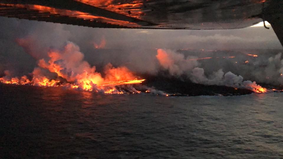
Fountains from Fissure 8 spatter cone continue to supply lava to the open channel with intermittent small, short-lived overflows. The spatter cone is now about 55 m (180 ft) tall at its highest point, and fountains rarely rise above that point. At the coast, the northern margin of the flow field is still oozing pasty lava at several points in the area of Kapoho Beach Lots. Lava was entering the sea over a broad area this morning primarily on the northern side of the flow front. As shown by the July 02 thermal map of the flow field, the lava channel has crusted over about 0.8 km (0.5 mi) inland of the ocean entry; lava is oozing from the flow’s molten interior into the ocean along most of its broad front.
Fissure 22 is spattering about 50-80 m above a conical spatter cone and feeding a short lava flow that is moving slowly to the northeast along the edge of earlier flows.
Pele’s hair and other lightweight volcanic glass fragments from the lava fountain at Fissure 8 continue to fall downwind of the fissure, dusting the ground within a few hundred meters (yards) of the vent. High winds may waft lighter particles to greater distances. Residents are urged to minimize exposure to these volcanic particles, which can cause skin and eye irritation similar to volcanic ash.
July 2, 2018 Lava Overflows Downslope from Mick Kalber on Vimeo.
HVO field crews are on site tracking the fountains, lava flows, and spattering from Fissure 8 as conditions allow and are reporting information to Hawaii County Civil Defense. Observations are also collected on a daily basis from cracks in the area of Highway 130; no changes in temperature, crack width, or gas emissions have been noted for several days.
The ocean entry is a hazardous area. Venturing too close to an ocean entry on land or the ocean exposes you to flying debris from sudden explosive interaction between lava and water. Also, the lava delta is unstable because it is built on unconsolidated lava fragments and sand. This loose material can easily be eroded away by surf, causing the new land to become unsupported and slide into the sea. Additionally, the interaction of lava with the ocean creates « laze », a corrosive seawater plume laden with hydrochloric acid and fine volcanic particles that can irritate the skin, eyes, and lungs.
Kīlauea Volcano Summit
At 02:17 AM HST July 3, a collapse explosion event occurred at Kīlauea’s summit. Heavy clouds obscured visual and radar measurement of the plume; however, ash-poor plumes have only risen 1,000-2,000 ft above the ground surface during recent similar events. The energy released by the event was equivalent to a M5.1 earthquake. After the collapse/explosive event, seismicity dropped abruptly for several hours but has since returned to 20-30 earthquakes per hour, a number of which are in the magnitude 2-3 range. Inward slumping of the rim and walls of Halemaʻumaʻu continues in response to ongoing subsidence at the summit.
Source : HVO
Photos : USGS , Scott Wilson , DB photos .
Video :Mick Kalber
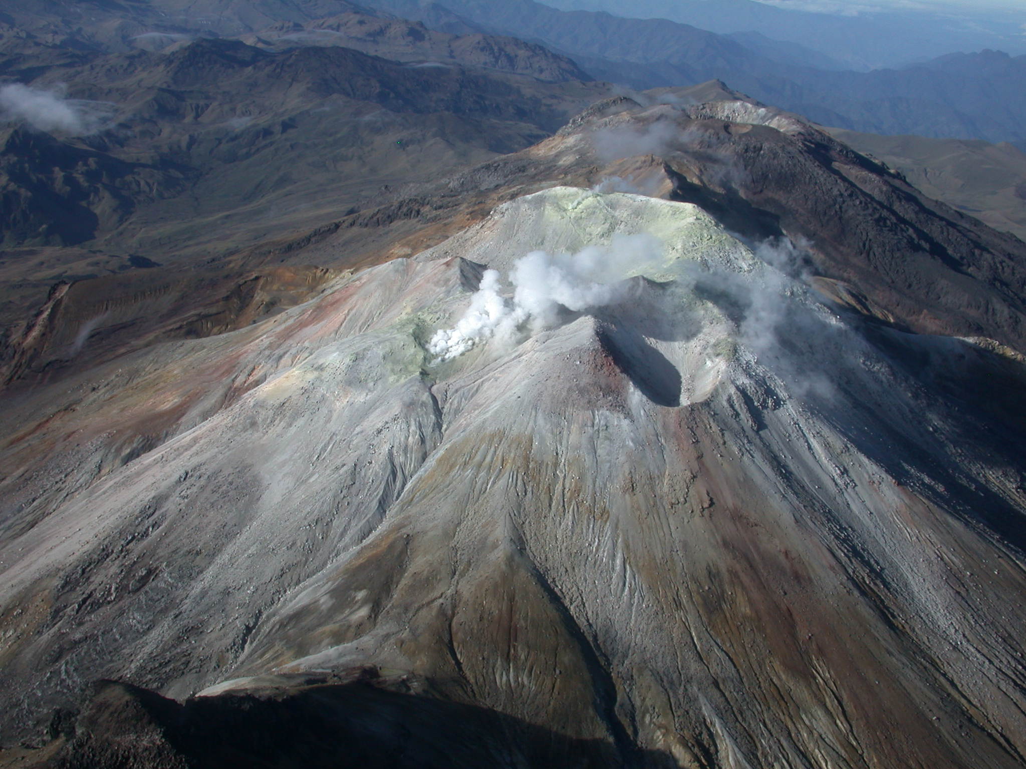
Peru : Sabancaya :
An average of 24 EXP / day was recorded. The earthquakes associated with the rise of the magma (Hybrid Types) remain very weak in number and energy.
The eruptive columns of gas and ash reached a maximum height of 2500 m above the crater. The dispersion of these materials occurred within a radius of about 30 km, mainly to the south, south-east and east. The volcanic gas (SO2) flow recorded on June 21st a maximum value of 3000 tons / day, a value considered large.
The deformation of the surface of the volcanic building does not present any significant variations.
The MIROVA satellite system recorded 6 thermal anomalies, with values between 2 MW and 22 MW VRP (Radiated Volcano Power).
In general, eruptive activity maintains moderate levels. No significant changes are expected in the following days.
Source : IGP
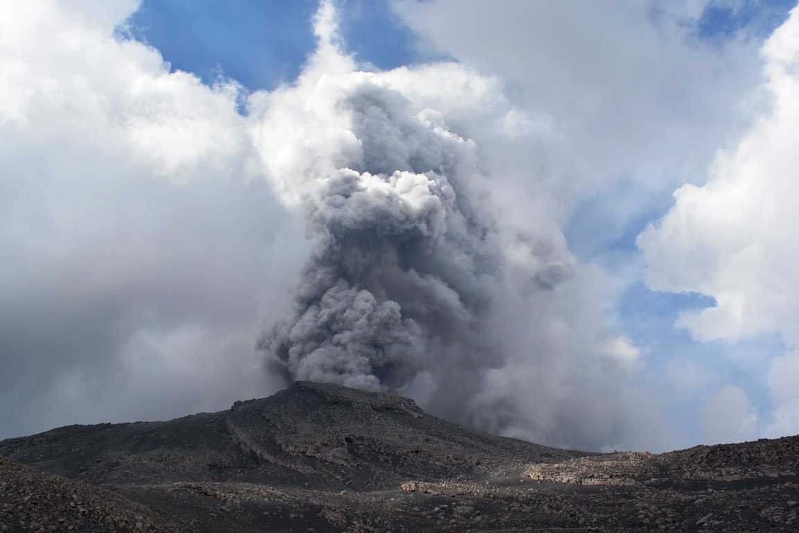
Indonesia : Anak Krakatau :
VOLCANO OBSERVATORY NOTICE FOR AVIATION – VONA.
Issued: July 03 , 2018 .
Volcano:Anak Krakatau (262000)
Current Aviation Colour Code: ORANGE
Previous Aviation Colour Code: orange
Source: Anak Krakatau Volcano Observatory
Notice Number: 2018KRA03
Volcano Location: S 06 deg 06 min 07 sec E 105 deg 25 min 23 sec
Area: Lampung, Indonesia
Summit Elevation: 976 FT (305 M)
Volcanic Activity Summary:
Eruption at 11:21 UTC (18:21 local time). Eruption and ash emission is continuing
Volcanic Cloud Height:
Ash cloud not visible.
Other Volcanic Cloud Information:
Ash cloud is moving to North. Anak Krakatau volcano is not clear and not visible.
Remarks:
continuous volcanic eruption.
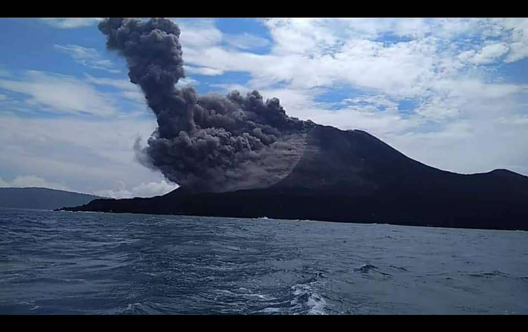
Level II Activity Level (WASPADA). The G. Anak Krakatau has increased its activity since June 18, 2018. From yesterday to this morning, visually the mountain is covered with fog. The wind is weak to moderate in the east and northwest.
The seismograph records of July 2, 2018 noted:
119 eruption earthquake
175 emission earthquakes
16 low frequency earthquakes
5 shallow volcanic earthquakes
1 volcanic earthquake
37 tremor events
Recommendations:
The company / tourists are not allowed to approach the crater within a radius of 1 km around the crater.
Source : Magma Indonésie , PVMBG.
Photo :Lanik / Aris Yanto 21 Juin 2018.
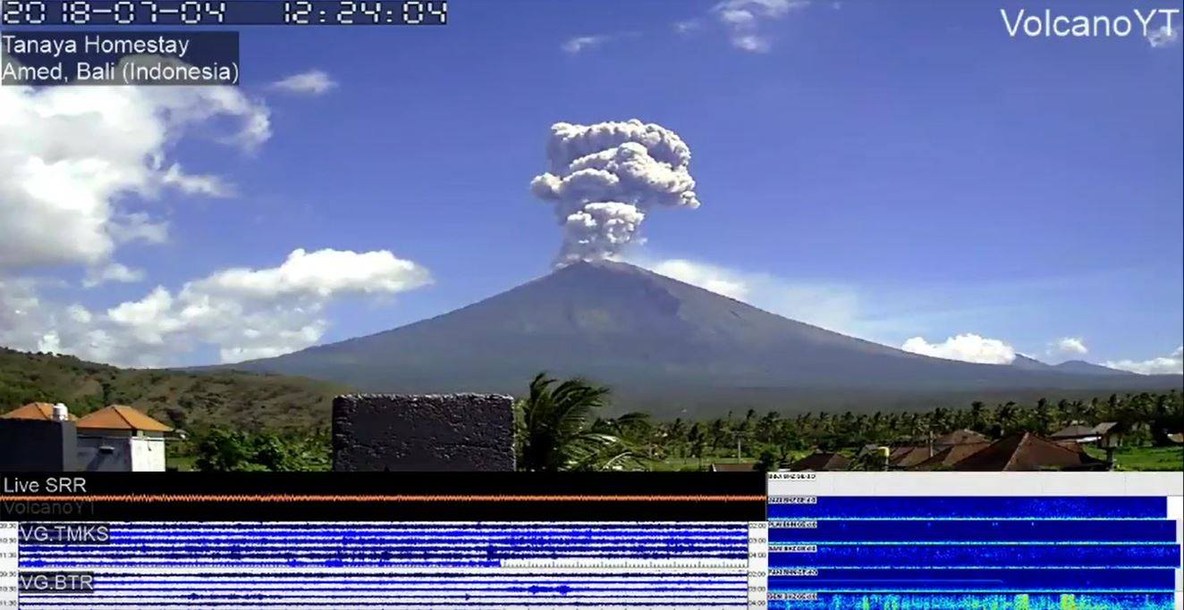
Indonesia : Agung :
The eruption of G. Agung, Bali occurred on 04 July 2018 at 12:20 WITA with a height of the ash column observed at ± 2,500 m above the peak (± 5,642 m above sea level) ). The gray columns were observed with a strong intensity, thick, inclined towards the West. This eruption is recorded on the seismogram with a maximum amplitude of 24 mm and a duration of ± 1 minute 58 seconds.
Currently G. Agung is at alert level III (SIAGA) with the recommendation:
-The communities around G. Agung and climbers / visitors / tourists must not climb and must not do any activity in the hazard estimation zone, ie in all zones within a radius of 4 km around G. Agung. The estimated area hazards are dynamic and continuously assessed and can be modified at any time based on the most recent observational data.
-People who live and move around streams coming down from Gunung Agung should be aware of the potential danger of falling mudslides, with thunderstorms that may occur, especially during the rainy season and when the material produced by the eruption is deposited in the area of the summit and remobilized.
Source : PVMBG
Colombia , Cumbal :
Subject: Cumbal Volcano Activity Bulletin.
The level of activity of the volcano is maintained at the level:
YELLOW LEVEL ■ (III): CHANGES IN THE BEHAVIOR OF VOLCANIC ACTIVITY
Following the activity of the CUMBAL VOLCANIC COMPLEX, the COLOMBIAN GEOLOGICAL SERVICE informs that:
For the week of June 26 to July 2, 2018, the seismic activity recorded an increase compared to the previous week, from 448 to 504 events, with the predominance of earthquakes associated with the movement of fluids inside the volcano Localized earthquakes showed a local magnitude lower than M1 on the Richter scale.
Atmospheric conditions favorable to the summit made it possible to observe gas emissions on July 1st and 2nd, mainly from the El Verde fumarole field in the North-East of the volcanic complex; the emission columns were observed of white color, of low height and direction of dispersion variable according to the direction of the wind.
The COLOMBIAN GEOLOGICAL SERVICE is attentive to the evolution of the volcanic phenomenon and will continue to inform in a timely manner of the detected changes.
Source : SGC
Guatemala : Fuego :
Volcanological SPECIAL BULLETIN BEFGO # 95-2018. Increased activity of Fuego volcano, Guatemala, July 3, 2018, 23:00 (local time)
Type of activity: Vulcanian
Morphology: Composite Stratovolcano
Location: 14 ° 28’54˝ Latitude N; 90 ° 52’54˝Longitude W.
Height: 3,763msnm.
The activity Fuego volcano persists with a lot of degassing since the crater, which disperses in a direction West and Southwest. Due to the eruption of June 3, the crater has become deep so that no activity of any kind can be observed. this time .
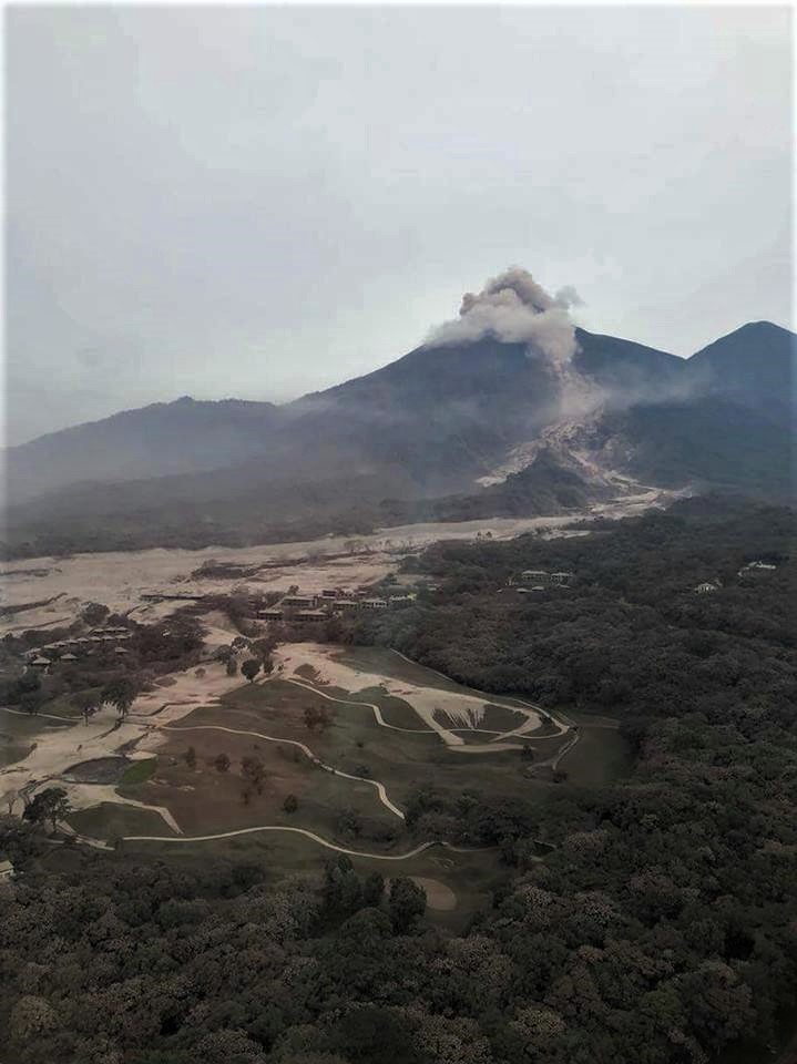
The seismic station FG3 has recorded a tremor (internal vibration) which may be associated with the pressure of magmatic gases and / or magma that migrate, increasing the pressure in the volcanic ducts.
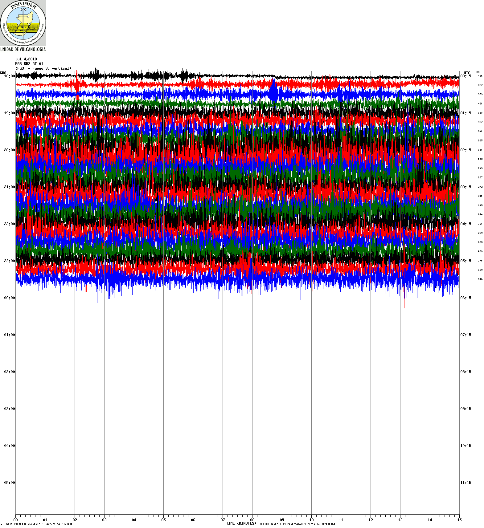
Due to this activity, in the next few hours, heavy cohesive ash explosions can be generated. This phase of activity is the first that has occurred for a month, so INSIVUMEH will continue monitoring the Fuego volcano.
Source : Insivumeh


No comment yet, add your voice below!