
June 08 , 2018.
Pu’u ‘Ō’ō / Kilauea , Hawai :
Wednesday, June 6, 2018, 10:41 PM HST (Thursday, June 7, 2018, 08:41 UTC)
19°25’16 » N 155°17’13 » W,
Summit Elevation 4091 ft (1247 m)
Current Volcano Alert Level: WARNING
Current Aviation Color Code: RED
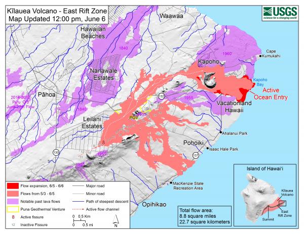
Kīlauea Volcano Lower East Rift Zone:
Vigorous eruption of lava continues from the lower East Rift Zone (LERZ) fissure system in the area of Leilani Estates.
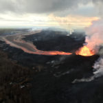
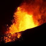
Lava fountaining at Fissure 8 continues, with fountain tops reaching heights of 130-210 feet, This activity is feeding a lava channel flowing east to the Kapoho Bay area. Lava is continuing to enter the ocean in the area of the Vacationland subdivision. A late afternoon overflight showed that the ocean entry is creating a vigorous steam plume that is being blown inland to the southwest. The delta that formed at Kapoho Bay extended slightly throughout the day, and a lateral lobe of the flow is pushing slowly north through what remains of the Kapaho Beach Lots subdivision..
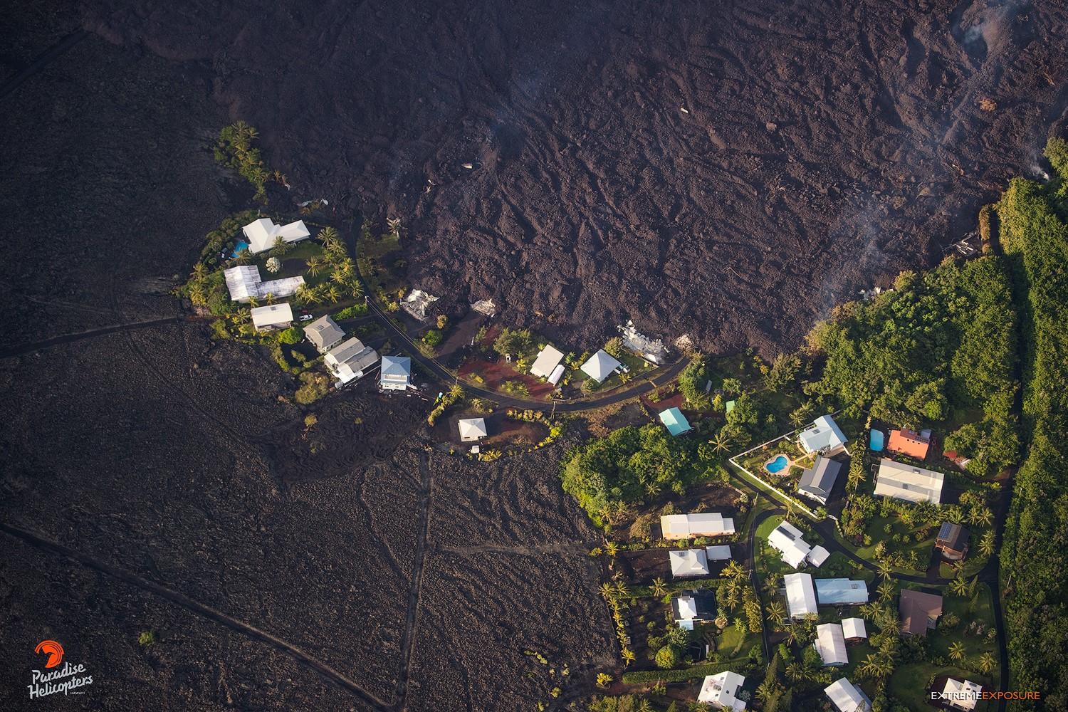
Wednesday, June 6, 2018, 5:45 am – Kilauea’s east rift zone overflight: This little cluster of homes, is the only thing that remains of Kapoho Beach Lots, while every single structure within Vacationland was consumed.
The northern lobe of the Fissure 8 flow appears to have stalled with only traces of smoke at the flow front, although there is some incandescence in the finger of that lobe that advanced along a low graben a few nights ago. No other fissures are active.
Pele’s hair and other lightweight volcanic glass from high fountaining of Fissure 8 are falling downwind of the fissure and accumulating on the ground within Leilani Estates. Winds may waft lighter particles to greater distances. Residents are urged to minimize exposure to these volcanic particles, which can cause skin and eye irritation similar to volcanic ash.
HVO field crews are on site tracking the fountains, lava flows, and spattering from multiple fissures as conditions allow and are reporting information to Hawaii County Civil Defense.
Volcanic gas emissions remain very high from the fissure eruptions. For the next few days wind conditions may bring vog not only to the south and west sides of the Island of Hawaii, but also the island’s interior.
Magma continues to be supplied to the lower East Rift Zone. Earthquake locations have not moved farther downrift in the past few days and the number of located earthquakes remains low. Seismicity remains relatively low with numerous small magnitude earthquakes and low amplitude background tremor.
Additional ground cracking and outbreaks of lava in the area of the active fissures are possible. Residents downslope of the region of fissures should heed all Hawaii County Civil Defense messages and warnings.
USGS/HVO continues to monitor the lower East Rift Zone activity 24/7 in coordination with Hawaii County Civil Defense.
Kīlauea Volcano Summit
A small explosion, with an equivalent earthquake magnitude of M5.6, occurred at 4.07 PM HST, generating an ash plume that rose to an elevation of about 10,000 feet. Since this small explosion, summit seismicity has dropped significantly, following the pattern of previous events. Inward slumping of the rim and walls of Halema`uma`u continues in response to ongoing subsidence of the summit.
Over the last week, sulfur dioxide emissions from the volcano’s summit have decreased, but emission rates remain high enough to impact air quality in downwind regions. Additional bursts of gas released with intermittent explosive activity are also transported downwind and may temporarily affect air quality as well.
Thursday, June 7, 2018, 8:50 AM HST (Thursday, June 7, 2018, 18:50 UTC)
Kīlauea Volcano Lower East Rift Zone
Vigorous eruption of lava continues from the lower East Rift Zone (LERZ) fissure system in the area of Leilani Estates.
Overnight, lava fountaining at Fissure 8 fluctuated, reaching heights of 230 feet. This activity is feeding a lava channel flowing east to the Kapoho Bay area. Observations by HVO geologists and the University of Hawaii at Hilo UAS crew during the night indicated that the northern lobe of the Fissure 8 flow is not receiving significant lava, and the lobe that was active on the west side of the Four Corners cinder pit is inactive. The morning overflight confirmed these observations and revealed minor overflows from the channel. Lava is entering the ocean along a broad front in the general area of Kapoho Bay and Vacationland. Lava also continues to creep north through what remains of Kapoho Beach Lots.
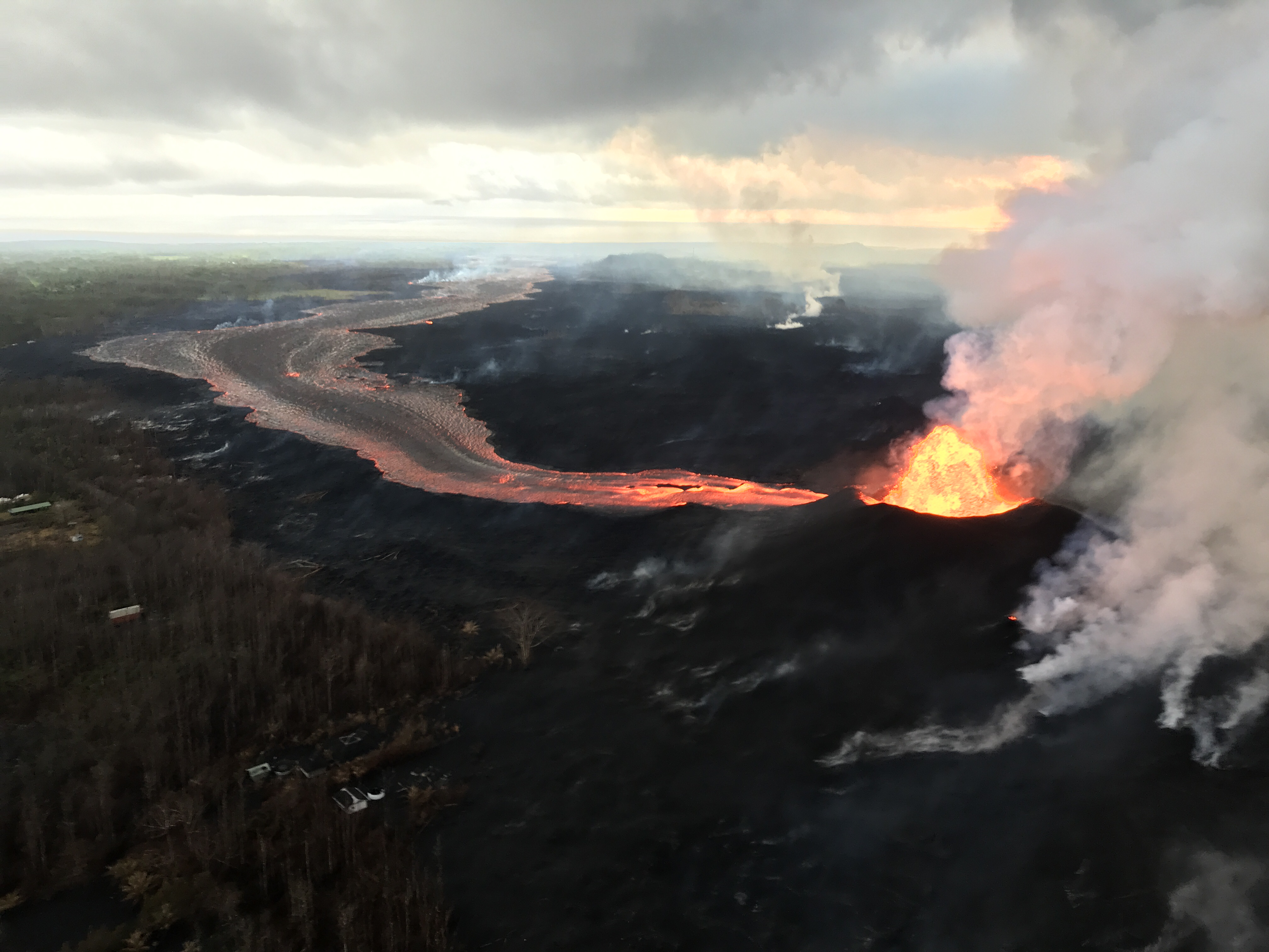
View of the fissure 8 lava fountain and lava channel that travels to the ocean, a distance of about 12.5 km (7.8 mi). Photo taken during this morning’s overflight at about 6:30 a.m. HST.
No other fissures are active.
Kīlauea Volcano Summit
Seismic activity at the summit was subdued overnight — a natural consequence of yesterday afternoon’s small explosion. Earthquake activity is on the rise, however, and we anticipate an additional small explosion probably in about 24 hours. Inward slumping of the rim and walls of Halema`uma`u continues in response to ongoing subsidence of the summit.
Thursday, June 7, 2018, 4:24 PM HST (Friday, June 8, 2018, 02:24 UTC)
Kīlauea Volcano Lower East Rift Zone
Vigorous eruption of lava continues from the lower East Rift Zone (LERZ) fissure system in the area of Leilani Estates.
Lava fountaining at Fissure 8 fluctuated with heights varying between 190 and 215 feet. This activity is feeding a lava channel flowing east to the ocean entry in the Kapoho Bay area. The noon overflight found that the delta is about 1.2 mi wide in the Vacationland/Waopae area and observed the flow was expanding northward through Kapoho Beachlots. A large area of upwelling offshore suggests the presence of lava flowing on the ocean floor in that area.
No other fissures are active.
Kīlauea Volcano Summit
Seismic activity at the summit was increasing slowly after yesterday afternoon’s small explosion. We anticipate an additional small explosion probably in about 24 hours. Inward slumping of the rim and walls of Halema`uma`u continues in response to ongoing subsidence of the summit.
Source : HVO
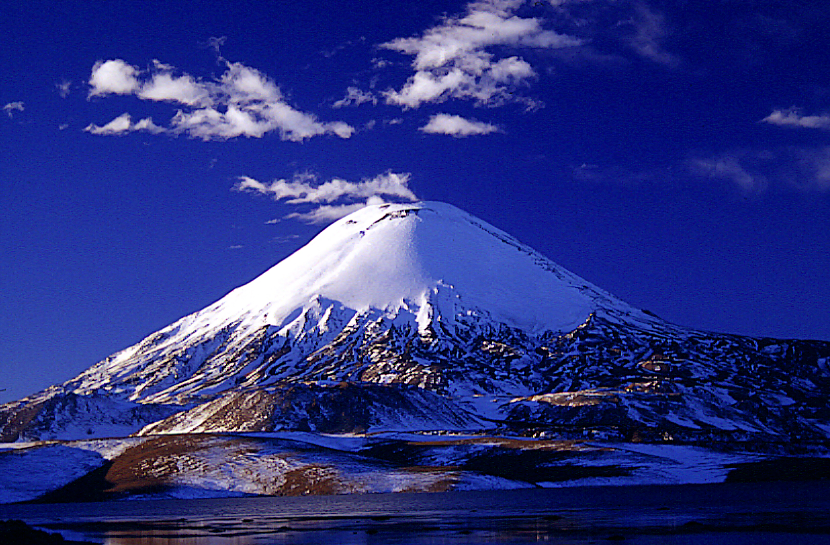
Parinacota , Chile :
Special Report on Volcanic Activity (REAV), Arica and Parinacota Region, Parinacota Volcano
06 June 2018.17: 03 Local time (mainland Chile)
The National Geological and Mining Service of Chile (Sernageomin) publishes the following PRELIMINARY information, obtained through the monitoring equipment of the National Volcanic Monitoring Network (RNVV), processed and analyzed at the Volcanological Observatory of the Andes. South (OVDAS):
Yesterday, Wednesday, June 6, at 17:03 local time (21:03 GMT), the monitoring stations installed in the vicinity of the Parinacota volcano recorded a seismic swarm of volcano-tectonic (VT) type events in connection with a fracturing process of rocks, comprising 90 earthquakes classified in a period of 85 minutes. The higher energy event had a local magnitude equal to M 2.3 and was located southwest of the volcano at a depth of 1.6 km.
Observations:
There are no reports from authorities or communities in general about a perception of this event in the area.
The level of technical alert is maintained at the level: GREEN.
Sernageomin conducts on-line monitoring and will inform any changes in volcanic activity in a timely manner.
Source: National Geological and Mining Service (Sernageomin), National Volcanic Surveillance Network (RNVV) Volcanological Observatory of the Southern Andes (Ovdas).
Photo : Andeshandbook.
Fuego , Guatemala :
SPECIAL BEFGO VULCANOLOGICAL BULLETIN # 44-2018 Guatemala 7 June 2018, 21:40 (local time).
PIROCLASTIC FLOWS IN THE RAVIN LAS LAJAS, VOLCANO OF FUEGO.
Type of activity: Vulcanian
Morphology: Composite Stratovolcan
Location: 14 ° 28’54˝ Latitude N; 90 ° 52’54˝ Longitude W.
Height: 3,763msnm
The seismic station FG3 is currently recording the descent of pyroclastic flows by the ravine Las Lajas and El Jute. It is estimated that this new stream produces an ash curtain that reaches 6,000 meters above sea level and will be dispersed mainly to the West and Southwest depending on the direction of the wind.
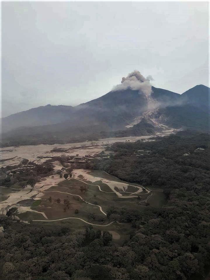
It is important to note that pyroclastic flows carry very hot gases and materials, so it is recommended not to stay in or near ravines. Due to the fact that the ravines are full of materials, it is possible for these pyroclastic flows to travel a greater distance and descend to the Guacalate River.
These events may continue to occur during the hours and days impacting the main ravines.
CONRED reported that by 0630 on 6 June a total of 12,089 people had been evacuated, with 3,319 people dispersed in 13 shelters. One bridge and two power networks had been destroyed. According to news sources on 6 June, Guatemala’s National Institute of Forensic Sciences stated that 75 people were confirmed to have died and 192 were still missing. Many, possibly thousands, received burns and other injuries. Weather conditions, continuing activity at Fuego, poor air quality, hot pyroclastic flow deposits, and rain made rescue efforts difficult.
Source : Insivumeh, GVP.
Galeras , Colombia :
Subject: Weekly activity bulletin of Galeras volcano
The level of activity of the volcano continues at the level:
YELLOW LEVEL ■ (III): CHANGES IN THE CONDUCT OF VOLCANIC ACTIVITY.
Following the activity of the GALERAS volcano, the COLOMBIAN GEOLOGICAL SERVICE informs that:
For the period from May 29 to June 4, 2018, there was an increase in both the occurrence of seismic events and released energy, most of them associated with rock fracturing. inside the volcanic building. The earthquakes were mainly located east-north-east with respect to the volcanic building with maximum distances of 8.8 km from the main crater, at depths between 1.9 and 9.6 km from the summit (level of reference at 4200 m) and local magnitudes up to M4 on the Richter scale. It is pointed out that on May 29 between 11:21 and 22:29, there were eight earthquakes that were reported as felt by the inhabitants of the area of Briceño to Pasto, these events had magnitudes between M0,8 and M2,1 on the Richter scale. In the same way for May 30 at 2:52. and on June 2 at 13:45, there were earthquakes with magnitudes of M1,4 and M3,0 respectively, which were reported as felt in different areas of the city of Pasto.

During the period under review, for days 29, 30, 31 May and 1 June and when climatic conditions in the volcano area were adequate, it was possible to observe the emissions of gases from the main fumarolic volcanic fields, at low outlet pressure, white in color, with little height and varying direction of dispersion depending on the predominant direction of the winds in the volcanic peak zone.
The COLOMBIAN GEOLOGICAL SERVICE remains attentive to the evolution of the volcanic phenomenon and will continue to inform in a timely manner of the observed changes.
Source : SGC


No comment yet, add your voice below!