May 9 , 2018.
Pu’u ‘Ō’ō / Kilauea , Hawai :
Monday, May 7, 2018, 5:59 PM HST (Tuesday, May 8, 2018, 03:59 UTC)
19°25’16 » N 155°17’13 » W,
Summit Elevation 4091 ft (1247 m)
Current Volcano Alert Level: WARNING
Current Aviation Color Code: ORANGE
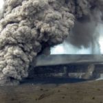
Lower East Rift Zone Eruption:
The intermittent eruption of lava in the Leilani Estates subdivision in the lower East Rift Zone of Kīlauea Volcano continues. The location of activity today was focused on the southwest portion of the area.

At 10:00 a.m. HST, steam rose from fissure 9 on Moku Street in the Leilani Estates Subdivision. HVO scientists on the scene reported hearing rumbling noises in the area.
This morning, two new fissure segments broke ground. The first (fissure 11) opened in a forested southwest of Leilani Estates about 9:30 am and was active for only 3 hours. The second (fissure 12) opened about 12:20 between older fissures 10 and 11. By 3:15 pm, both new fissures were in active but the west end of fissure 10 was steaming heavily.
Cracks on Highway 130 widened from 7 cm to 8 cm over the course of the day and additional cracks were found just west of the highway on trend with the eruptive fissures.
Tuesday, May 8, 2018, 8:15 AM HST (Tuesday, May 8, 2018, 18:15 UTC)
Summary:
As of 7:00 am, the eruption along Kīlauea Volcano’s lower East Rift Zone within the Leilani Estates subdivision has paused. Strong emission of gas continues from the fissure system that is now about 2.5 miles long. This pause is likely temporary and resumption of lava emission or additional fissure outbreaks are possible at any time.
Deflationary tilt at the summit of the volcano continues and the lava lake level continues to drop. There is no active lava in the Puʻu ʻŌʻō area. Aftershocks from Friday’s magnitude-6.9 earthquake continue and more are expected. Rockfalls into the Overlook vent within Halemaʻumaʻu crater are producing intermittent ash emissions. Seismicity at Kīlauea’s summit remains elevated.
USGS/HVO continues to monitor the situation 24/7 in coordination with Hawaii County Civil Defense and other authorities. Field crews are onsite this morning examining the fissure vents, lava flow of yesterday, and searching for any signs of new or resumed activity.

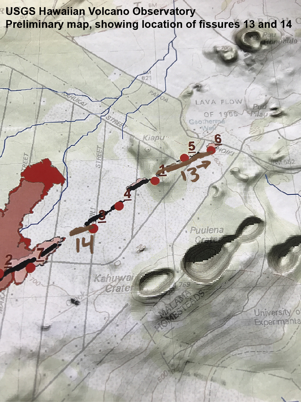
At 2:47 p.m. HST. A new fissure (13) erupted across Leilani Street. View is toward the southwest on Leilani Street near the intersection with Pohoiki Road. Fissure 13 is located between fissures 1 and 6.
Lower East Rift Zone Observations
Lava emission from fissures was minimal overnight. Strong degassing continues from several fissures. There was no active lava flowing as of 7:00 am this morning.
Deformation of the ground in the area continues. Ground cracks are reported crossing Highway 130 about 1 mile west of the westernmost fissure.
Overall seismicity in the area has not changed significantly overnight and remains elevated. Seismic stations nearest the fissures record seismicity likely related to ongoing vigorous degassing.

Summit Observations:
Tiltmeters at the summit continue to record a deflationary trend of the past week and the summit lava lake level continues to drop. Elevated summit sulfur dioxide emission rates persist.
Rockfalls into the Overlook crater are intermittently producing small ash emissions that loft several thousand feet above the ground and travel downwind.
Elevated earthquake activity in the summit area continues following Friday’s magnitude-6.9 earthquake and as a consequence of ongoing summit deflation.
Puʻu ʻŌʻō Observations:
A tiltmeter on the Puʻu ʻŌʻō cone continues to record the deflationary pattern that followed collapse of the crater floor on April 30. Rockfalls from the steep crater walls will likely continue to collapse intermittently, producing small ashy plumes. The 61g lava flow is no longer active.
Hazard Analysis:
Continued eruptive activity (fluctuating and intermittent) in the lower East Rift Zone is likely. New outbreaks or resumption of lava production at existing vents can occur at any time.
Areas downslope of erupting fissures are at risk of lava inundation. The general area of Leilani Estates remains at the greatest risk. However, as the eruption progresses, other areas of the lower East Rift Zone may also be at risk.
High levels of volcanic gas including sulphur dioxide are being emitted from the fissure vents. In addition, smoke from burning houses and burning asphalt is a health concern and should be avoided.
As the lava lake level inside Halemaʻumaʻu drops, rockfalls from the enclosing walls may increase in frequency prompting explosions of spatter from the lake onto the nearby crater rim and lofting plumes of ash. Dustings of ash from these events can occur downwind.
Additional aftershocks from the magnitude-6.9 earthquake are expected and some may be strong.
East Rift Zone Eruption EMERGENCY UPDATE
Civil Defense Emergency Message for Tuesday, May 8, 2018 at 2:30 PM.
Eruption update:
EVACUATION – Hawaiian Volcano Observatory confirms 2 new vents. All Lanipuna residents must evacuate now. Evacuate towards the ocean Isaac Hale Beach Park. Vent number 13 has opened near the intersection of Leilani Avenue and Kahukai Road and Vent number 14 near Kaupili St. and Leilani Avenue. Both are actively erupting.
Source : HVO
Photos : HVO , Ryan Finlay.
Vidéos : HVO
Source : HVO
Piton de la Fournaise , La Réunion :
Activity Bulletin from Tuesday, May 8, 2018 at 16:30 (local time).
The eruption started on April 27, 2018 at 23:50 local time continues. After a gradual decline observed for three days, the intensity of the volcanic tremor (indicator of surface eruptive intensity) has been relatively stable for 24 hours (Figure 1).
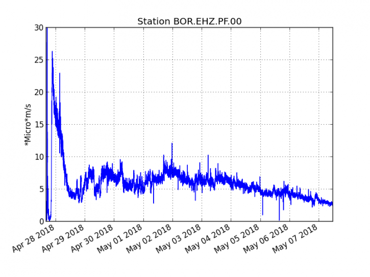
Figure 1: Evolution of RSAM (Indicator of Volcanic Tremor and Eruption Intensity) between 20:00 (16:00 UTC) April 27 and 16:00 (16:00 UTC) May 8 at the BOR Seismic Station (at the top) . (© OVPF / IPGP)
– The surface flows estimated from the satellite data, via the HOTVOLC platform (OPGC – Clermont Ferrand), recorded today were always between 1 and 2.5 m3 / s.
– No significant deformation is recorded.
– No volcano-tectonic earthquake has been recorded during the last 24 hours under the Piton de la Fournaise building.
Alert level: Alert 2-2 – Eruption in the Enclos.
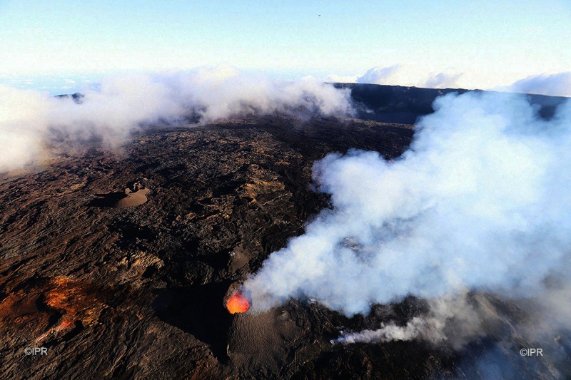
While the Piton de la Fournaise continues to erupt, many fires broke out at the foot of the rampart and even in the rampart. On Monday, the flames spread along the cliff, blazing the vegetation. An incident that required the intervention of firefighters, remained on site for a surveillance mission.
Back in pictures on this hot incident in a video signed Alain Bertil.
Source : OVPF. Zinfos974.
Photo : IPR
Video : Zinfo974 , Alain Bertil.
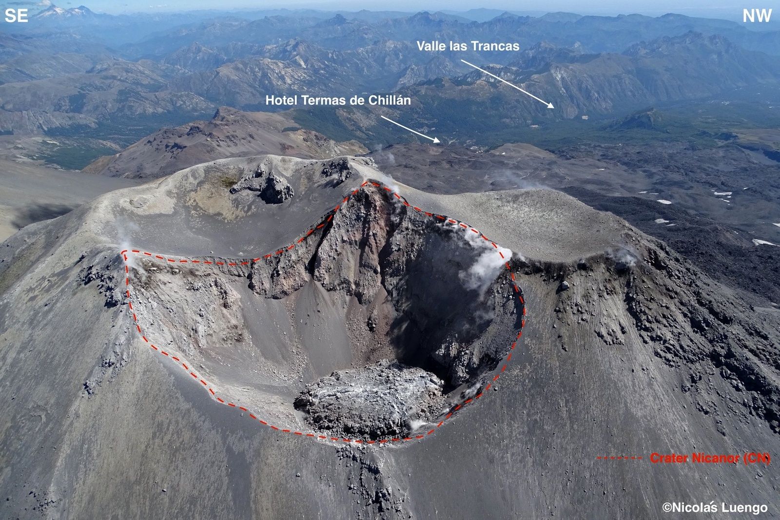
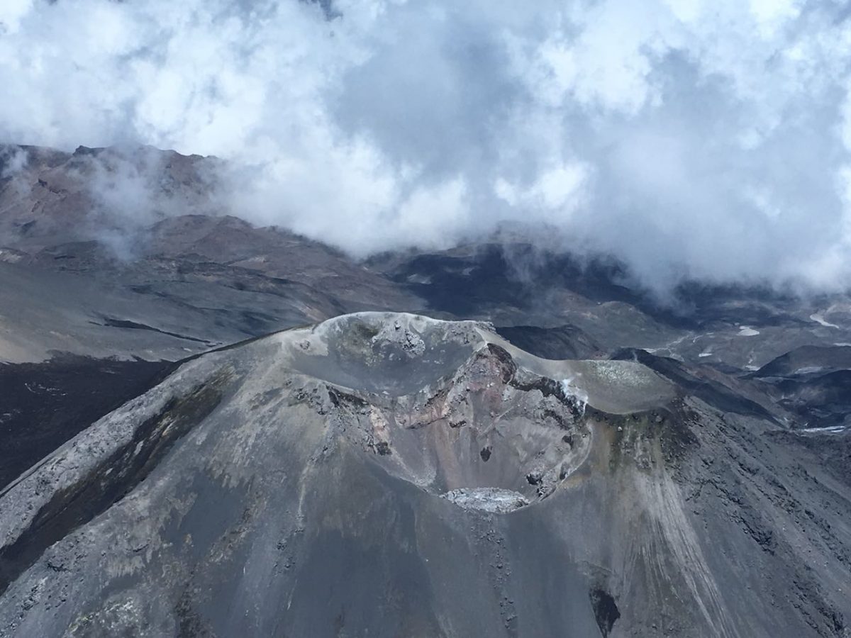
Nevados de Chillan , Chile :
Volcanic Activity Report (VAR), Volcanological Observatory of the Southern Andes – Ovdas
Date: 06 May 2018 16h30 HL.
Current alert level: ORANGE
1. Volcanic monitoring
1.1 Seismic activity:
During the last 24 hours, through the monitoring of the Nevados del Chilian volcanic complex, it has been observed an increase in the seismic energy of earthquakes related to the occurrence of explosions, the permanence of the seismicity of long period type (LP) and tremor episodes (TRs) most of them with moderate seismic energies. In addition, the onset of each explosion was often accompanied by LP-type earthquakes followed by tremor episodes, as well as seismic signals related to the frequency of explosions (EX) at shallow levels and the process of extrusion of the lava dome into the active crater.
1.2 Surface activity
Maximum height of the column (km): 0.2.
Direction: South.
Main distance Panache (km): not detected.
Source of information: OVDAS IP camera
Incandescence (yes / no): Yes
Observations:
DR (Reduced Displacement) values are related to the size of the seismic signals. The recording of an explosion of moderate to high intensity was highlighted, at 08:05 HL today, with a DR of 533 cm2. Because of the presence of clouds it was not possible to observe its development on the surface.
The active degassing column of this process showed a correspondence with the seismicity record. From the camera of the Ovdas, presented a vertical direction, whitish coloring, and direction of dispersion preferably towards the South-Southeast. At night, there is an incandescence, sometimes accompanied by ballistic projections reaching a maximum height of 100 m above the edge of the crater.
1.3 Other observations
Infrasound sensors recorded during the period acoustic signals due to explosions with amplitudes less than or equal to 3.5 pascals (Pa) reduced to 1 km.
⦁ Thermal radiation information processed by the MIROVA group reported a 2 MW thermal anomaly on Nevados del Chilian.
The area of potential danger is determined on the basis of a moderate to high explosive eruptive phase, associated with a partial destruction of the lava dome nestled in the active crater. The procedure planned before this event would be the generation of a 10-kilometer high eruptive column that collapses, which could generate pyroclastic surges that would radially affect the crater.
Eventually, depending on the availability of sediments and water, flooding may occur in the large valleys draining the Las Termas sub-complex, mainly towards Estero Renegado, Shangri-La Valley, the Rio’s headwaters. Nuble. In addition, the gravitational collapse of the lava dome of the Northeast crater is envisaged, which could affect the Gato and Las Minas rivers through pyroclastic flows, ash and boulders.
Finally, the most likely scenario is the sporadic generation of minor eruptive impulses (columns no greater than 5 km altitude) associated with explosions of gas, pyroclastic particles whose ballistic projections fluctuate over a distance of 2 to 3 km around the active crater.
Source : Sernageomin
Photo : N. Luengo.
Popocatépetl , Mexico :
May 7, 11:00 h (May 7, 16:00 GMT).
In the last 24 hours, through the Popocatepetl volcano monitoring systems, 81 low intensity exhalations accompanied by water vapor and gas were identified. Additionally, three volcanotectonic earthquakes were recorded, two yesterday at 15:15 and 17:39, and the last today at 01: 54h, all with a magnitude of 1.8.
During the night, incandescence was observed that increased at the time of some exhalations .
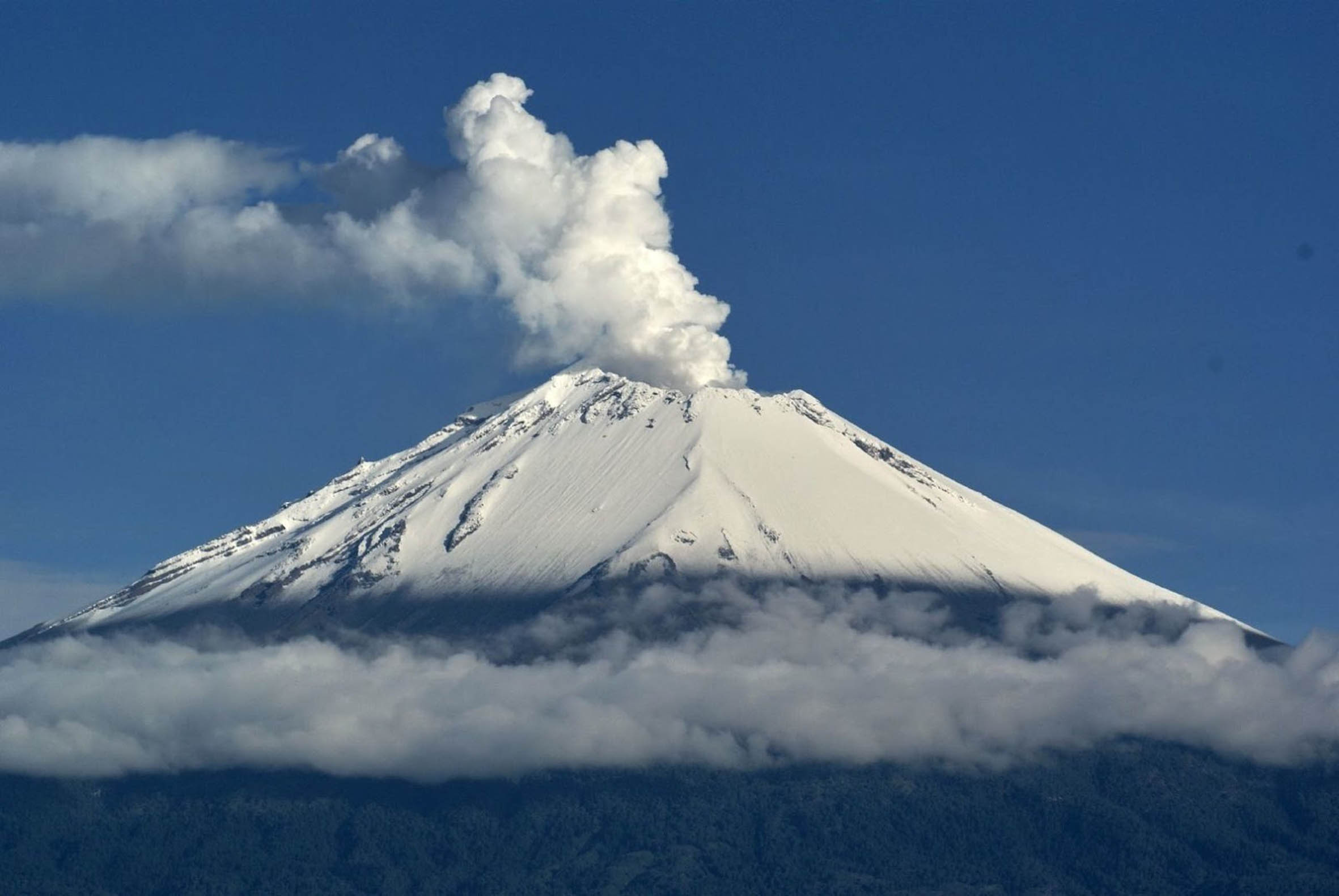
At the time of this report, the crater of the volcano is not observed, however in the morning it was possible to see an emission of water vapor and gas with south-southwest direction .
CENAPRED urges NOT TO APPROACH the volcano and above all the crater, due to the danger of the fall of ballistic fragments (image 5) and in case of heavy rains to move away from the bottoms of ravines due to the risk of landslides and mudflows.
The Popocatepetl Volcanic Alert Traffic Light is located in Amarillo Phase 2.
Source : Cenapred.
Osorno , Chile:
Recurrent volcano-tectonic seismicity recorded continuously shows a gradual increase, both in the number of events and in their magnitude.

Locations on the volcanic building are concentrated on the north-northwest flank (NNW) of the crater, suggesting the onset of processes of greater instability of the volcanic system. For the above, his level of volcanic alert is changed to level:
YELLOW LEVEL: Changes in the behavior of volcanic activity – Probable time for an eruption: WEEKS / MONTH.
Source : Sernageomin


No comment yet, add your voice below!