
April 16 , 2018.
Sinabung , Indonesia :
Visual:
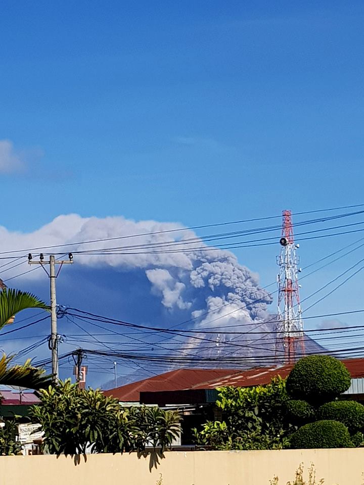
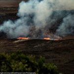
As of 15/04/2018 at 08:27, an eruption of the Sinabung volcano with high ash column of 1000 meters has occurred, with a mild-moderate wind directed towards the West-North-West. The aftershocks lasted until 22:03. There were 13 eruptions behind with a column height that tended to decrease. So far, we have not observed the presence of hot clouds that accompany this eruption.
Seismicity:
On seismic monitoring, the recorded eruption earthquakes started at 20h27 with a maximum amplitude of 46 mm for 602 seconds, and to date the eruption is still in progress with a maximum amplitude reduced to 20 mm.
Potential threats:
• The explosive eruption still has the potential to occur.
• Threats of heavy ash rains can reach up to 3 km and depend on the direction and strength of the wind.
• Hot eruption clouds potentially threaten the South-South-East sector up to 7 km and the South-East sector up to 6 km.
• Activity on the new Smoke Emission Pit on the North Slope (Lau Kawar) is still ongoing.
The steps that have been implemented:
1. Coordinate with related agencies: Karo BPKD, Karo BPBD, Kualanamu Airport Party (Vona report)
2. Conduct continuous monitoring of the volcanic activity of Sinabung
Recommendations:
Community and visitors / tourists should not operate within a radius of 3 km around the summit, 7 km away in the southeastern sector of G. Sinabung, which is located in the valley of openings potentially affected by Hot Clouds: Pasarpinter Gurukinayan, Sibintun / Perjumaan Batukejan intersection, Benuken Tigapancur Lau Bridge, Tigapancur-Pejumaan Tigabogor Village, Pintumbesi Village and Jeraya Village, and at a distance of 6 km in the Southeast Sector, located in the Valley of openings potentially affected by pyroclastic clouds: village Kutatengah, and at a distance of 4 km in the northern sector, likely to be affected by ashes on this slope: village of Kutagugung.
Source: Centre de Volcanologie et d’Atténuation des Risques Géologiques, Agence Géologique, Ministère de l’EDDM, Magma Indonésie.
Photo : Sadrah Peranginangin.
Galeras , Colombia :
Subject: Weekly activity bulletin of the Galeras volcano.
The level of activity of the volcano continues at the level:
YELLOW LEVEL ■ (III): CHANGES IN THE CONDUCT OF VOLCANIC ACTIVITY.
Following the activity of the GALERAS volcano, the COLOMBIAN GEOLOGICAL SERVICE informs that:
During the period between April 3 and April 9, 2018, low levels of activity are maintained both in the onset of seismicity and in the released energy observed during recent periods. Recorded earthquakes have been associated with a fracturing process of solid materials in the volcanic edifice and are scattered around the bottom of the active cone, less than 7 km from the top (4200 m) and with minor local amplitudes of M 0.5 on the Richter scale.

Favorable climatic conditions made it possible to record the processes of gas emission, with columns of low height and variable dispersion according to the prevailing wind regime.
The COLOMBIAN GEOLOGICAL SERVICE is attentive to the evolution of the volcanic phenomenon and will continue to inform in a timely manner of the detected changes.
Source : SGC
Fuego , Guatemala :
Type of activity: Vulcanian
Morphology: Composite Stratovolcano
Location: 14 ° 28’54˝ Latitude N; 90 ° 52’54˝ Longitude W.
Height: 3,763 meters above sea level
Weather conditions: Clear
Wind: South-South at 6 km / h
Precipitation: 3.5 mm
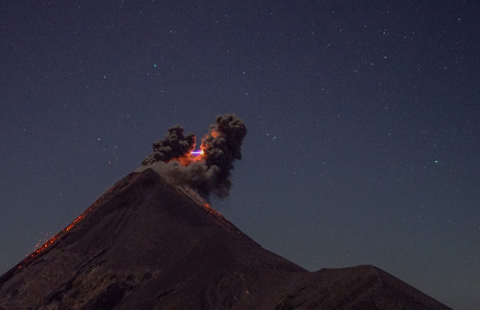
Activity:
The Fuego Volcano Observatory reports explosions in a range of 7 to 9 per hour, moderate and strong, emitting thick plumes of gray ash, at a height of about 4,800 meters (15,748 feet), dispersed to the east. West and South, for a distance of 20 kilometers. The explosions generate moderate rumblings, strong shock waves and degassing sounds every 6 minutes or so. At night, incandescent pulses are observed at a height between 250 and 300 meters above the crater, generating weak to moderate avalanches around the crater. Fine ash falls are recorded in the communities of Panimache I and II, Morelia, Santa Sophia, El Porvenir and Palo Verde Estate, among others located in this direction.
Source : Insivumeh.
Photo : M. Rietze.
Mayon , Philippines :
MAYON VOLCANO BULLETIN 15 April 2018 08:00 A.M.
Mayon Volcano’s seismic monitoring network recorded one (1) volcanic earthquake during the past 24 hours. Weak to moderate emission of white steam-laden plumes that crept downslope towards the west-southwest and southwest was observed throughout the day. Fair crater glow from the summit could be observed at night. Sulfur dioxide (SO2) emission was measured at an average of 1,621 tonnes/day on 12 April 2018. Medium-term deflation has been recorded by electronic tiltmeter since 20 February 2018 despite short-term episodes of inflation at the lower and middle slopes. Precise leveling data obtained on 22-29 March 2018 indicate deflation of the edifice relative to the 10-19 March 2018 surveys. However, overall ground deformation data indicate that the edifice is still inflated relative to pre-eruption baselines.
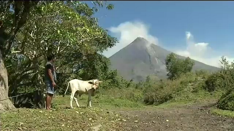
Alert Level 2 currently prevails over Mayon Volcano. This means that Mayon is at a moderate level of unrest. DOST-PHIVOLCS reminds the public of sudden explosions, lava collapses, pyroclastic density currents or PDCs and ashfall can still occur and threaten areas in the upper to middle slopes of Mayon. DOST-PHIVOLCS recommends that entry into the six kilometer-radius Permanent Danger Zone or PDZ and a precautionary seven kilometer-radius Extended Danger Zone or EDZ in the south-southwest to east-northeast sector, stretching from Anoling, Camalig to Sta. Misericordia, Sto. Domingo, must be strictly prohibited. People residing close to these danger areas are also advised to observe precautions associated with rockfalls, PDCs and ashfall. Active river channels and those perennially identified as lahar prone areas in the southern and eastern sectors should also be avoided especially during bad weather conditions or when there is heavy and prolonged rainfall. Civil aviation authorities must advise pilots to avoid flying close to the volcano’s summit as airborne ash and ballistic fragments from sudden explosions and PDCs may pose hazards to aircrafts.
DOST-PHIVOLCS is closely monitoring Mayon Volcano’s activity and any new significant development will be immediately communicated to all stakeholders.
Source : Phivolcs.


No comment yet, add your voice below!