
March 19 , 2018.
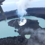
Ambae , Vanuatu :
15°24’0”S 167°50’0”E
Summit 4908ft (1496m)
Current Vanuatu Volcano Alert Level: Level 3
Vanuatu’s Ambae volcano rumbling again
19 MARCH 2018. Volcanic activity on Vanuatu’s Ambae island has picked up again, with fresh ashfall reported across the island’s west and south. The entire island was evacuated late last year when the volcano at the island’s centre erupted, blanketing the island in ash, suffocating crops and contaminating water.
The population returned when the eruption settled down after a month, but last night, the volcano’s alert level was raised from level 2 to 3 — what’s called a « state of minor eruption. » The Geohazards Department’s Melinda Aru said the volcano was showing increased activity and an exclusion zone had been extended to three kilometres around the crater lake.
« We’ve got a few reports coming from Ambae concerning ashfall on the west, southwest and northwest as of last week until yesterday. We still have reports from Ambae concerning ash fall. » Melinda Aru said the chance of the eruption increasing to the level seen in October is highly unlikely.
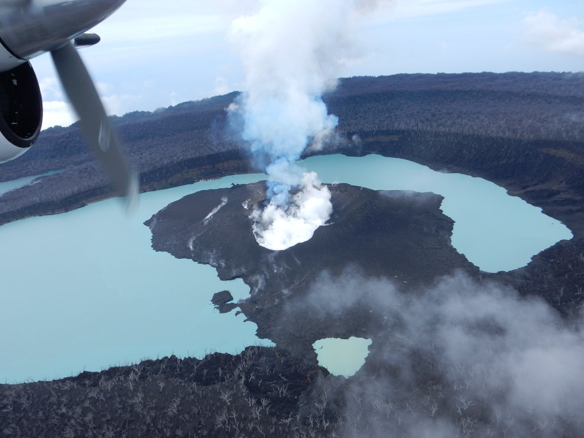
Ambae volcano is in the minor eruption state; Its Alert Level is raised from Level 2 to Level 3 .
The volcanic eruption at Ambae confined inside the Lake Voui is stable at Alert Level 3. Scientific analyses confirm that the current activity is similar to the volcanic activity at the end of October 2017 but with more and sustained emissions of volcanic ashes. The possibility of imminent increasing activity is very low. The restricted area of risk is now limited to the area of 3 km from the active vent.
Observations of February and March 2018 confirm that the activity is continuing from the recent edified volcanic cone (island). Style of Ambae volcano activity is explosive, similar to what is seen and experienced at Yasur on Tanna Island. Explosions are accompanied by volcanic ashes and/or gases cloud. With the current size of the volcanic cone in Lake Voui, people from Ambae may hear explosions, view a minor volcanic ash and/or gas plume and glows over the mountain at night.

These observations and the analysis of seismic data confirms that the volcano activity is in the level of minor eruption state. The volcano activity consist of ongoing emission of ashes, gases and volcanic bombs that may fall around the volcano vents.
Based on its slight decreased seismic activity and observation of ongoing volcanic gas emission and steam plumes on the web camera, the Volcanic Alert Level (VAL) at Ambae was dropped to Level 2 on 7th December 2017. The current activity shows ongoing ashes and gases emission causing more impact to villages. This is consistent with the Alert Level 3 activity. Level 3 indicates ‘Minor eruption; Danger is now at 3 km around the volcanic vent and areas that exposed to the wind direction’ . The possibility that the Ambae volcano activity escalate to the level of moderate eruption is very low .
Source : Radio NZ , Geohazard.
Photo : David Sarginson.
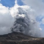
Mayon , Philippines :
MAYON VOLCANO BULLETIN 19 March 2018 08:00 A.M.
Mayon’s activity in the past 24 hours was characterized by general quiescence, degassing from the summit crater and gravity-driven lava flow. Weak emissions of white steam-laden plumes drifting southwest occurred throughout the day. Lava flows could be observed at night to be moving downslope on the Miisi, Bonga and Basud Gullies within 3.3 kilometers, 4.5 kilometers and 1.9 kilometers of the crater, respectively. A total of seventy (70) rockfall events were recorded by Mayon’s seismic monitoring network. Sulfur dioxide (SO2) emission was measured at an average of 1895 tonnes/day on 18 March 2018. A slight inflation of the lower flanks beginning 11 March 2018 was recorded by electronic tilt, consistent with results of Precise Leveling (PL) surveys on 03 – 06 March 2018. Overall ground deformation data indicate that the edifice is still swollen or inflated relative to pre-eruption baselines.
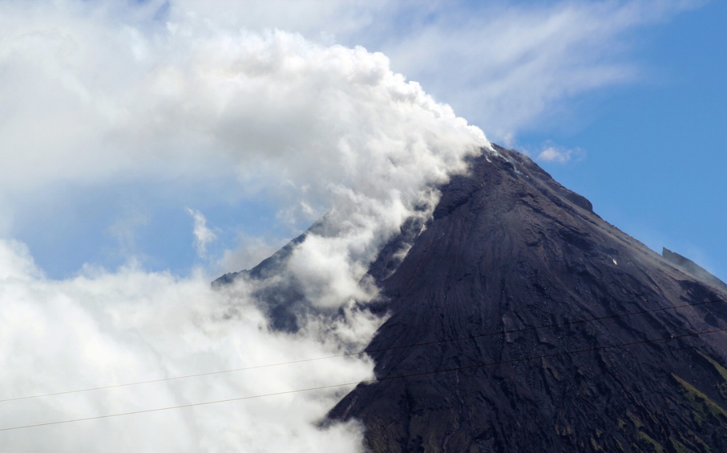
Alert Level 3 currently prevails over Mayon Volcano. This means that although Mayon’s unrest continues, there is a decreased likelihood of hazardous explosive eruption to occur. PHIVOLCS-DOST reminds the public of sudden explosions, lava collapses, pyroclastic density currents or PDCs and ashfall can still occur and threaten areas in the upper to middle slopes of Mayon. PHIVOLCS-DOST recommends that entry into the six kilometer-radius Permanent Danger Zone or PDZ and a precautionary seven kilometer-radius Extended Danger Zone or EDZ in the south-southwest to east-northeast sector, stretching from Anoling, Camalig to Sta. Misericordia, Sto. Domingo, must be strictly prohibited. People residing close to these danger areas are also advised to observe precautions associated with rockfalls, PDCs and ashfall. Active river channels and those perennially identified as lahar prone areas in the southern and eastern sectors should also be avoided especially during bad weather conditions or when there is heavy and prolonged rainfall. Civil aviation authorities must advise pilots to avoid flying close to the volcano’s summit as airborne ash and ballistic fragments from sudden explosions and PDCs may pose hazards to aircrafts.
PHIVOLCS-DOST is closely monitoring Mayon Volcano’s activity and any new significant development will be immediately communicated to all stakeholders.
Source : Phivolcs
Nevados de Chillan , Chile :
During this period, seventy-five (75) earthquakes classified as volcano-tectonic events (VT) were recorded, related to fracturing processes of rigid materials, with a maximum local amplitude (ML) of 2.4. The strongest earthquake was 4.2 km southeast (SE) of the active crater at a depth of 2.5 km.
Similarly, four thousand nine hundred and thirty (4030) earthquakes associated with fluid dynamics within the volcanic building were recorded, of which two thousand eight hundred and twenty-three (2823) were classified as long-period type events. (LP), with a maximum displacement value (DRC) of 177.7 cm2. Similarly, one thousand two hundred and sixteen tremor events (TR) were recorded, the largest of them with a duration of about 2 minutes and a reduced average maximum displacement of 285.2 cm2.
Between March 1st and 15th, a total of eight hundred (800) explosions were reported, mainly associated with magmatic gases and / or recording of acoustic signals picked up by the microphones array near the volcano, which a maximum pressure of 0.4 Pa at 1 km distance, during the highest recorded explosion.
The images obtained through the cameras installed near the volcanic complex, showed mainly gas emissions associated with the explosions, coming from the craters currently active with column heights lower than 1300 m compared to the level of the crater. In addition, at night, the cameras recorded sporadic glow associated with some explosions and / or increased gas emissions from the active crater.
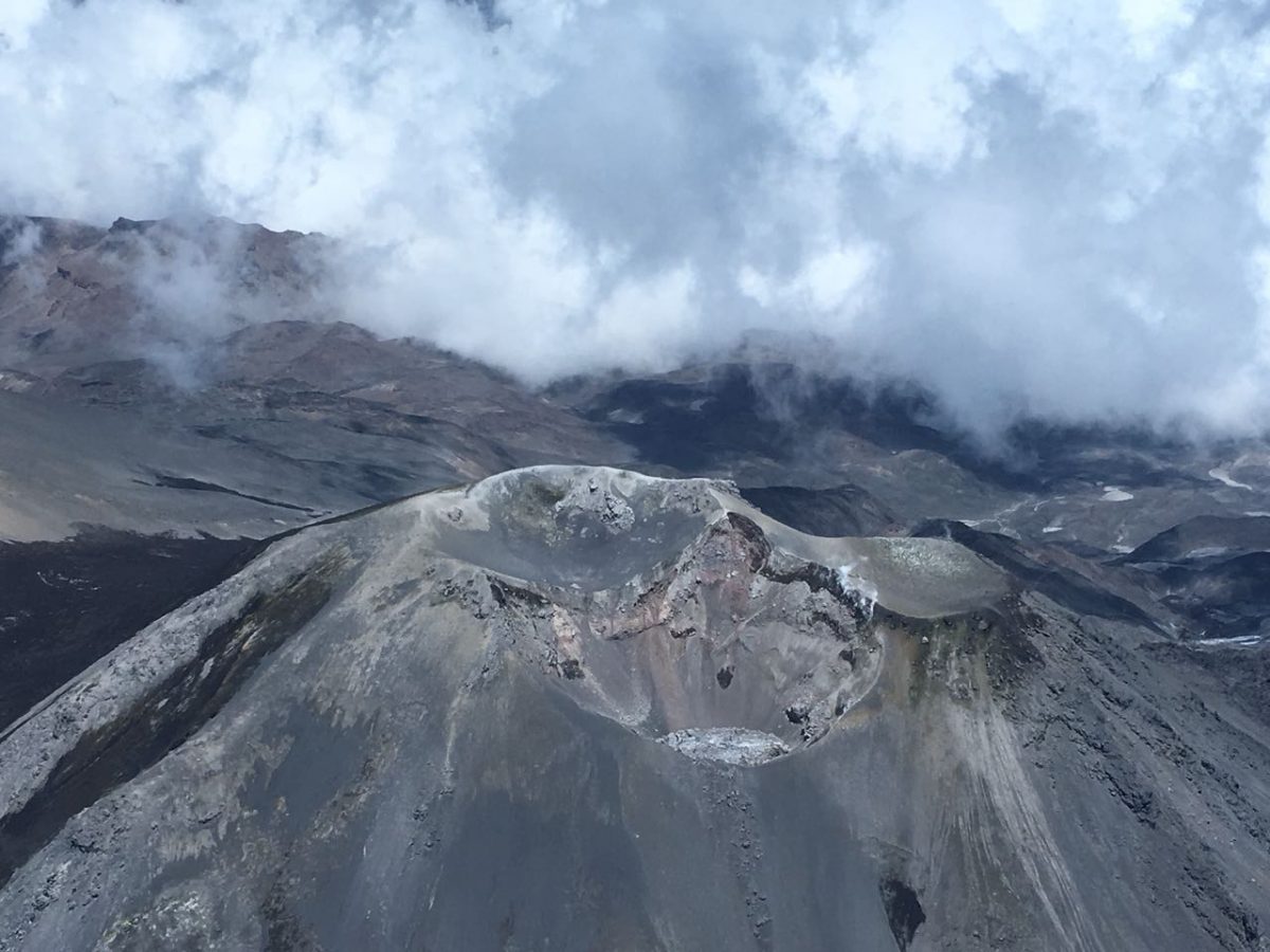
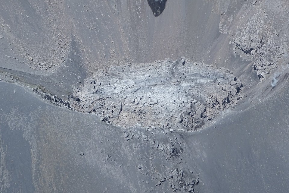
In order to find information on the growth of the dome located in the active crater, Sernageomin, with the collaboration of the Onemi, made an overflight on March 12, during which it was possible to measure a maximum temperature of 330 ° C on the dome G. Cruz, and note an increase in its extruded volume, which reaches a volume of about 100,000 m3, with a height greater than the lower edge of the crater. There is a persistence of almost uniform extrusion of the order of 0.017 m3 / s, in agreement with the released seismic energy. Finally, there are morphological changes in the area of the dome, with the presence of fracture lines and the formation of blocks.
The deformation recorded during this period continues to be of very small amplitude.
– Sulfur dioxide dioxide (SO2) emissions recorded by the Differential Absorption Spectrometer (DOAS) are at low levels, consistent with the presence of a lava dome. In addition, no SO2 emissions have been reported to the atmosphere in the volcanic complex sector, as published by the Sulfur Dioxide Group, Ozone Monitoring Instrument (OMI) (http: // so2). .gsfc.nasa.gov /) and the National Environmental Satellite Data and Information Service (NESDIS) (http://satepsanoine.nesdis.noaa.gov).
No thermal warnings based on data processed by mean infrared observation of volcanic activity (Mirova) (http://www.mirovaweb.it/) have been reported.
Given the scenario, a partial or complete collapse of the dome accompanied by depressurization of the magmatic bodies and the generation of Vulcanian explosions, volcanic processes can be triggered with ballistic projections and the generation of pyroclastic flows in areas near the volcano. In addition, it is possible that a smaller eruptive column is formed, which could generate a pyroclastic dispersion with a preference towards the East and the area of the Las Trancas Valley. Finally, the valleys of the Gato River, the Las Minas River and the Nubian River can be affected by low volume lahars. This scenario is subject to updates according to the evolution of the eruptive process.
In this context, the development of volcanic seismicity and its characteristics, as well as other monitoring parameters, together with permanent visual aerial observations to control the growth of the dome, will allow to diagnose the evolution of the process.
For this reason, special attention and a volcanic technical alert are maintained at the level:
YELLOW LEVEL: Changes in the behavior of volcanic activity – Probable time for an eruption: WEEKS / MONTH.
Observation: The potential area of assignment is 4 km around the active crater, added to the Gato valleys, the Las Minas River and the upper Nubian River, located northeast (NE) of the active volcanic building. In the current state, these channels can be affected by low volume lahars.
Source : Sernageomin.
Satsuma-Lojima , Japan :
The weather agency raised the volcanic alert level Monday for Satsuma-Iojima Island in Kagoshima Prefecture, southwestern Japan, citing an increase in volcanic earthquakes.
The Japan Meteorological Agency raised the alert level for the volcano from 1 to 2 on a scale of 5, warning against approaching the crater. It had previously advised people that the volcano is active.
The agency warned that areas within approximately 1 kilometer of the crater could be affected by flying rock if an eruption occurs.
It observed volcanic temblors on the island 12 times on Thursday and 51 times as of 11:30 a.m. Monday. The number has been increasing since mid-February, it said.
On Friday, the agency also confirmed a type of tremor that indicates underground magma activity.
![]()
Kikai is a mostly submerged, 19-km-wide caldera near the northern end of the Ryukyu Islands south of Kyushu. Kikai was the source of one of the world’s largest Holocene eruptions about 6300 years ago. Rhyolitic pyroclastic flows traveled across the sea for a total distance of 100 km to southern Kyushu, and ashfall reached the northern Japanese island of Hokkaido. The eruption devastated southern and central Kyushu, which remained uninhabited for several centuries. Post-caldera eruptions formed Iodake lava dome and Inamuradake scoria cone, as well as submarine lava domes. Historical eruptions have occurred in the 20th century at or near Satsuma-Iojima (also known as Tokara-Iojima), a small 3 x 6 km island forming part of the NW caldera rim. Showa-Iojima lava dome (also known as Iojima-Shinto), a small island 2 km east of Tokara-Iojima, was formed during submarine eruptions in 1934 and 1935. Mild-to-moderate explosive eruptions have occurred during the past few decades from Iodake, a rhyolitic lava dome at the eastern end of Tokara-Iojima.
Sources : Kyodo news , GVP


No comment yet, add your voice below!