
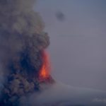
January 24 , 2018.
Mayon , Philippines :
MAYON VOLCANO BULLETIN 24 January 2018 8:00 A.M.
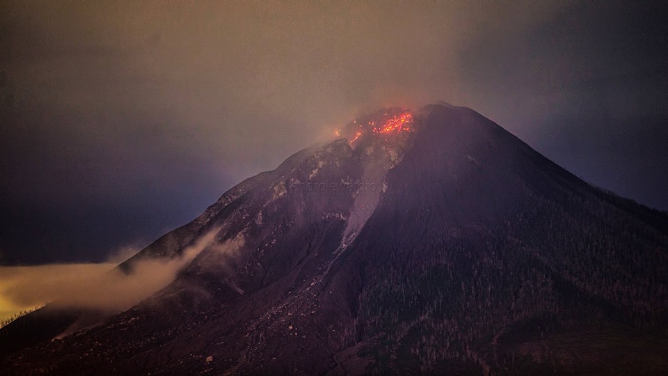
Between 08:54 AM yesterday to 03:57 AM this morning, five (5) episodes of intense but sporadic lava fountaining from the summit crater lasting seven (7) minutes to one (1) hour and twenty (24) minutes occurred. The lava fountains reached 500 meters to 600 meters high and generated ash plumes that reached 3 kilometers to 5 kilometers above the crater. The events fed lava flows on the Miisi and Bonga Gullies, sprayed near-vent lava spatter, and fed incandescent rockfall on the summit area. Pyroclastic density currents or PDCs on gullies heading the Miisi, Lidong/Basud, and Buyuan Channels were also observed. The runout of PDCs on the Buyuan Channel is now exceeding 5 kilometers from the summit crater.
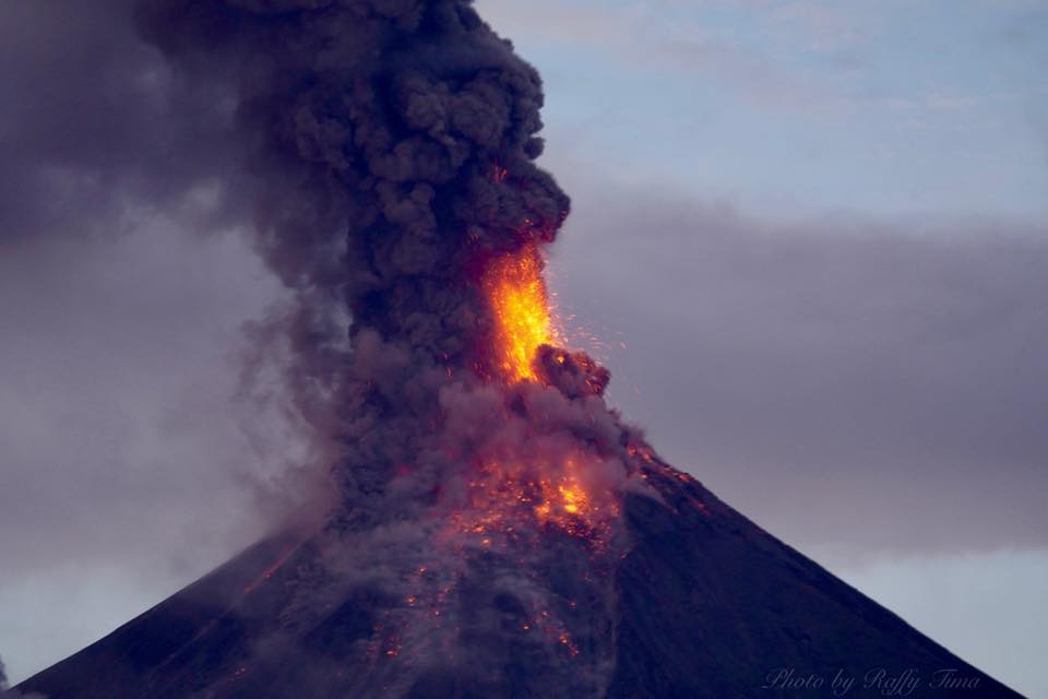
A total of five (5) tremor events corresponding to lava fountaining episodes, three (3) episodes of pyroclastic density current or PDC generation from lava collapse, and numerous rockfall events were recorded by Mayon’s seismic monitoring network. Rockfall events were generated by the collapsing lava front and margins of the advancing lava flow on the Miisi Gully and by shedding from the summit dome onto the Bonga Gully. Currently, the Miisi and Buyuan lava flows have advanced to three (3) kilometers and one (1) kilometer, respectively, from the summit crater. Sulfur dioxide gas emission was measured at an average of 2466 tonnes/day on 23 January 2018. Electronic tilt and continuous GPS measurements indicate a sustained swelling or inflation of the edifice since November and October 2017, consistent with pressurization by magmatic intrusion.
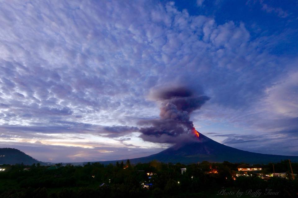
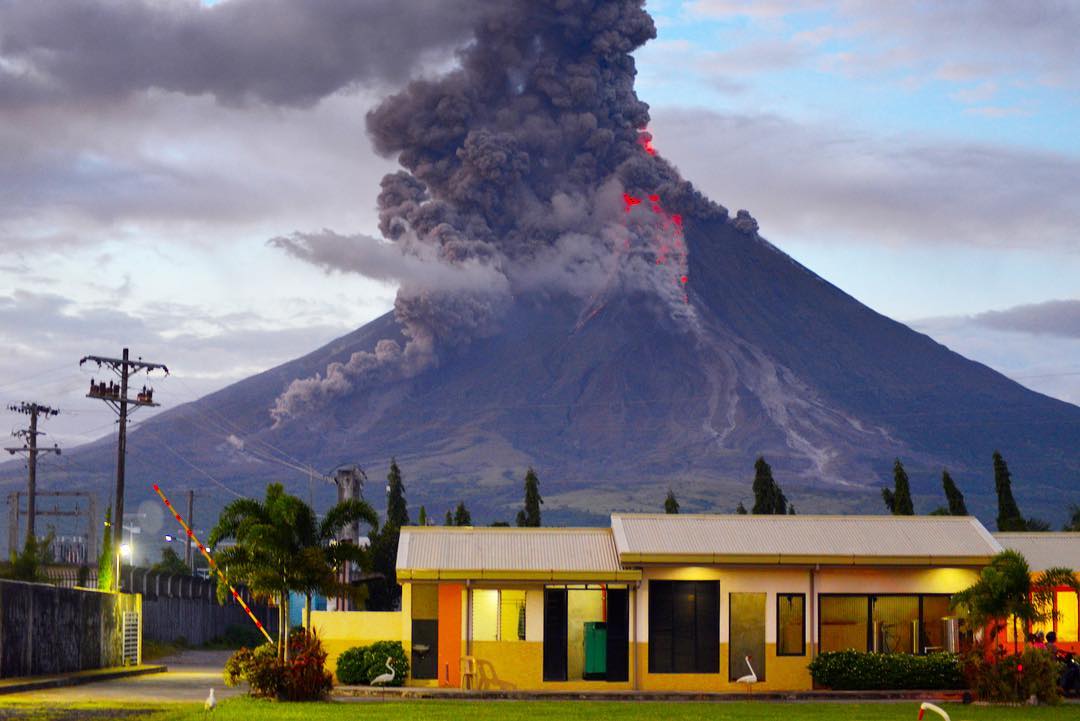
Alert Level 4 remains in effect over Mayon Volcano. The public is strongly advised to be vigilant and desist from entering the eight (8) kilometer-radius danger zone, and to be additionally vigilant against pyroclastic density currents, lahars and sediment-laden streamflows along channels draining the edifice. Civil aviation authorities must also advise pilots to avoid flying close to the volcano’s summit as ash from any sudden eruption can be hazardous to aircraft.
DOST-PHIVOLCS maintains close monitoring of Mayon Volcano and any new development will be communicated to all concerned stakeholders.
A province in the Philippines stops work, flying , in the middle of heavy volcanic ash falls.
MANILA (Reuters) – A central Philippine province has suspended its work Tuesday for its public and private offices in at least three cities following the activity of the country’s most active volcano.
The Philippine Civil Aviation Authority (CAA) said it had closed Legazpi Airport in Albay province because of ash falls, affecting nine international flights and 16 domestic flights.
The Mayon volcano was placed just one step below the highest alert level of 5 since Monday, when it emitted a greater volume of lava, ash and a mixture of gas, rock debris and water than scientists call « pyroclastic currents ».
Al Francis Bichara, governor of Albay and chairman of his disaster agency, said he had suspended office work in three cities due to heavy ash.
The danger zone around the 2,462-meter (8,077-foot) volcano has been extended to a radius of 9 kilometers (5.6 miles). Bichara said about 40,000 residents sought temporary shelter in the evacuation centers.
« Some people outside the danger zone are scared, so we must also welcome them, » he added.
Sources : Phivolcs , Reuters .
Photos : Jeff Canoy , Raffy Tima .
Cumbal , Colombia :
Subject: Cumbal Volcano Activity Bulletin.
The level of activity of the volcano is maintained at the level:
YELLOW LEVEL ■ (III): CHANGES IN THE CONDUCT OF VOLCANIC ACTIVITY
Following the activity of the CUMBAL VOLCANIC COMPLEX, the COLOMBIAN GEOLOGICAL SERVICE informs that:
For the week between January 16 and January 22, 2018, the seismic activity slightly increased in frequency during the previous week, from 245 to 328 events, mainly earthquakes related to the movements of fluids from a transient source in the time . Most of the seismic fracture events were located near the Mundo Nuevo crater (southwest of the Cumbal volcanic complex), with depths up to 7 km from the upper (4700 m) and local maximum magnitude of M1,1 on the Richter scale.
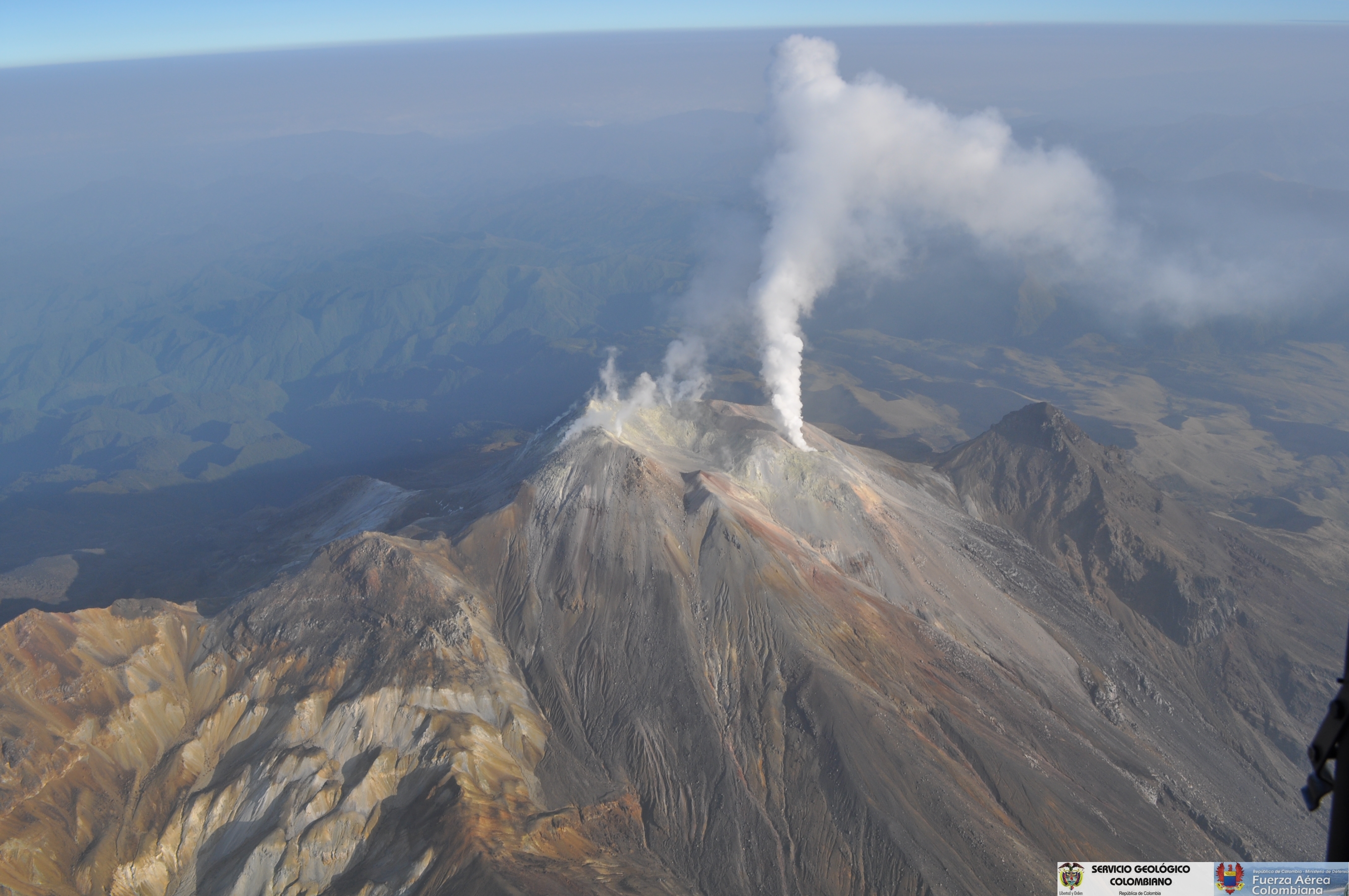
Favorable climatic conditions on the summit made it possible to record the gas emissions of January 16th from the El Verde fumarole fields, to the North-East of the volcanic complex; the emission columns were observed white, of low height and direction of dispersion variable by the action of the wind.
The COLOMBIAN GEOLOGICAL SERVICE continues to monitor the evolution of the volcanic phenomenon and will continue to report if changes are detected.
Source : SGC
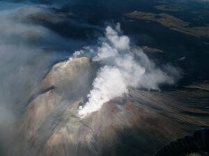
Sinabung , Indonesia :
VOLCANO OBSERVATORY NOTICE FOR AVIATION – VONA.
Issued: January 23 , 2018.
Volcano: Sinabung (261080)
Current Aviation Colour Code: ORANGE
Previous Aviation Colour Code: orange
Source: Sinabung Volcano Observatory
Notice Number: 2018SIN62
Volcano Location: N 03 deg 10 min 12 sec E 98 deg 23 min 31 sec
Area: North Sumatra, Indonesia
Summit Elevation: 7872 FT (2460 M)
Volcanic Activity Summary:
Eruption with ash clouds at 01h18 UTC (08h18 local time) January 23 , 2018 . Eruption and ash emission is continuing.
Volcanic Cloud Height:
Best estimate of ash-cloud top is around 17472 FT (5460 M) above sea level, may be higher than what can be observed clearly. Source of height data: ground observer.
Other Volcanic Cloud Information:
Ash-cloud moving to east – southeast.
Remarks:
Seismic activity is characterized by the Deep Volcanic Earthquake, Low Frequency Earthquake, and Hybrid Earthquake.
Level IV Activity Level (AWAS). The Sinabung (2460 m altitude) has been erupting constantly since 2013. Since yesterday until this morning was often covered with fog. The smoke that rises from the crater, during the periods when the volcano was discovered, could be observed rising from 50 to 1500 m above the volcano, with a low pressure, a color ranging from white to gray and an intensity moderate. The wind is blowing moderately towards the East – South – East.
Avalanche events with slip distances of 500 to 1500 m were recorded on the South, South – East and East slopes.
According to the recording of the seismographs of January 23, 2018, it was recorded
2 eruption earthquakes
50 avalanche earthquakes
24 low frequency earthquakes
1 earthquake of phase .
1 earthquake of emission.
Recommendations:
Communities / visitors should not do activities within 3 km of the summit, and by sector, 7 km to the South-South-East, 6 km East-South-East and 4 km to the South-East. km northeast.
The deposits formed a dam upstream on the Laborus River. People living in downstream river basins and around the Laborus River need to be vigilant because these dams can collapse at any time and no longer retain water volume, resulting in downstream lahars / floods .
Source : VSI , Magma.
Photo : Endro Lewa ( 21/01)
San Miguel ( Chaparrastique ) , El Salvador :
Special Report No. 3
The seismicity of the Chaparrastic volcano presents changes.
Date and time of issue: January 22, 2018, 10:00.
From Sunday, January 14 to Wednesday, January 17, 2018, the Chaparrastic volcano presented four gas emissions accompanied by ash. These pulses did not exceed 300 meters in height, indicating their low amplitude. In all four cases, the activity was preceded by a decrease in seismicity of the volcano, which then increased suddenly.
The volcano continues to show degassing and changes in seismic behavior, as shaking bands lasting up to 20 minutes followed by periods of calm are recorded, showing the movement of fluids in the internal system of the volcano. , indicating that it is active.
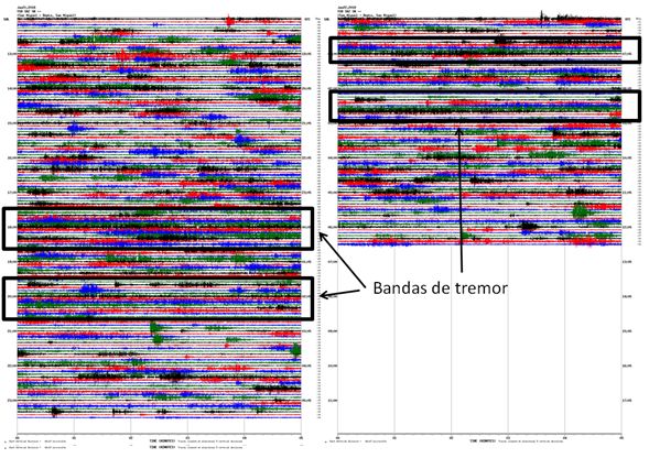
Figure 1. Evolution of seismicity associated with the movement of magmatic fluids.
On Friday, January 19th, the Local Observer Network recorded the emission of gas that the volcano presented in the morning.
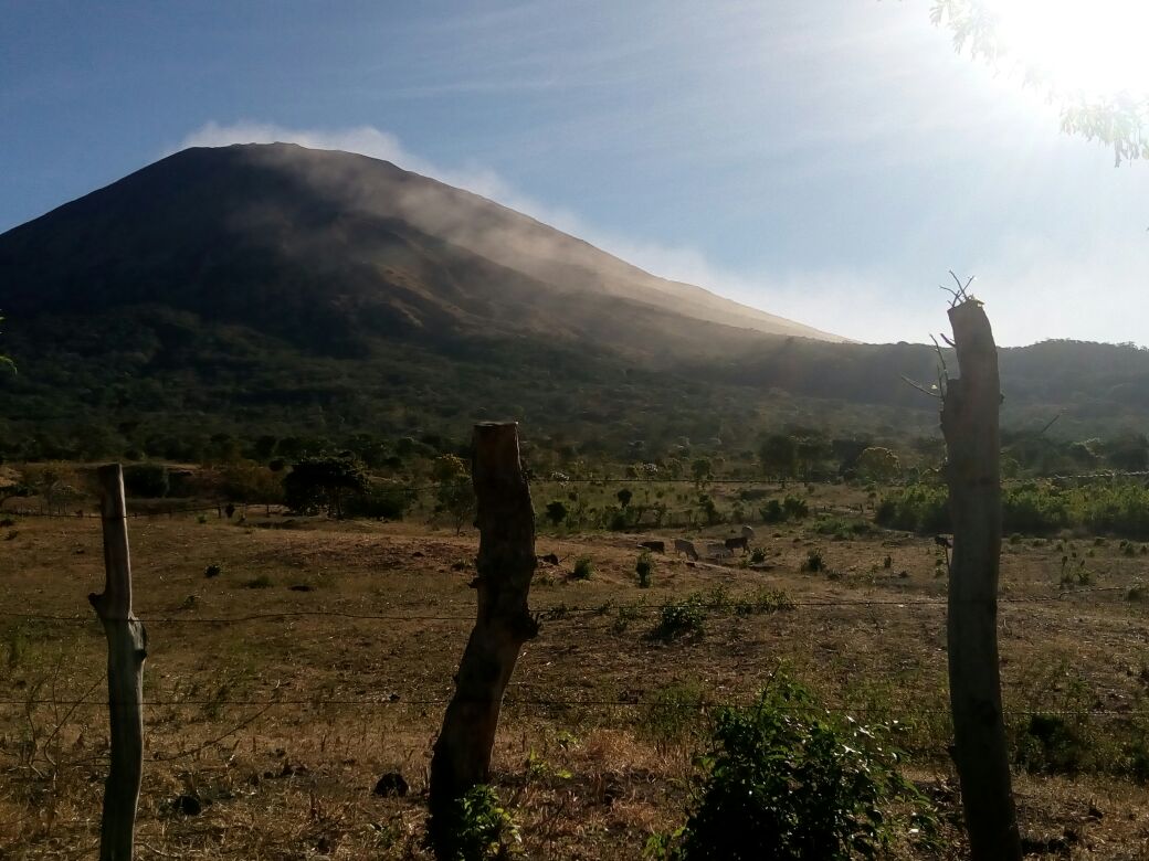
Figure 2. Degassing of the volcano descending the slope. Photo taken by a member of the local network of observers.
The MARN continues the systematic monitoring of the volcano and maintains close communication with the Directorate General of Civil Protection and local observers. In addition, it invites tourists and mountaineers to stay away from the upper part of the volcano because, often, there are sudden changes in activity.
The volcano maintains the emission of gas, however, changes in seismicity indicate that the fluids continue to move inside the volcano, so it is not excluded that it will present new episodes with gas emissions and ashes as presented in 2014 (16 issues); 2015 (three issues) and 2016 (five issues). It should be noted that during the month of January 2016, the volcano emitted ashes for 13 hours. If changes in seismicity continue, the volcano could continue to emit gases and ashes within days or even weeks to come.
Source : Snet
No comment yet, add your voice below!