
January 18 , 2018.
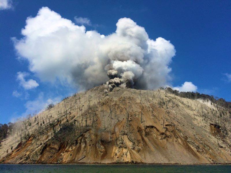
Kadovar , Papua New Guinea :
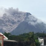
The current reports issued today by the PNG Rabaul Volcano Observatory of the Department of Mineral Policy & Geohazard Management on the Kadovar Volcano is that it is still erupting.
The Main Crater produced weak to moderate grey ash clouds to 300 meters above the vent, at long intervals with stronger sustained explosive activity producing ash clouds to 500-800 meters above the summit and is being blown to the South and South West, towards the Sepik River.
Whilst a Rabaul Volcano Observatory team was installing a seismometer on Kadovar they witnessed one moderate Vulcanian event with glowing rocks expelled. The South West and West Vents are both producing weak emissions but are often obscured by ash from the Main Crater.
A moderate continuous white steam plume is rising from the South East Coastal Vent to 800 meters above the island. The South East Coastal Vent emits a steady red glow at night with some periods of fluctuating glow intensity.
Downwind areas are affected by light haze. Discrete Vulcanian explosions will add pulses of higher ash loads and Seismometers have now been operating since 11:00 am (Local Time) on Blup Blup and at 15:00 pm (Local Time) since Tuesday on Kadovar. Between 11 am yesterday and 8:00 am this morning the Blup Blup seismometer recorded 6 discrete high frequency earthquakes and as for Kadovar earthquakes were at 2 seconds intervals from 14-15 km deep. The volcano is now being seismically monitored in almost real-time, if the situation escalates the number of earthquakes would be expected to increase in number and strength.
The situation is also being monitored by various satellite techniques. The recording of high frequency earthquakes from Kadovar indicates ‘rock breaking events’ and indicates the structure is still being stressed and the situation is dynamic.
The Risk level at the moment on the Island is HIGH. And on the Mainland and other nearby Islands, there is a small risk of TSUNAMIS happening.
Source : pngfacts.com .
Photo : us4.campaign.
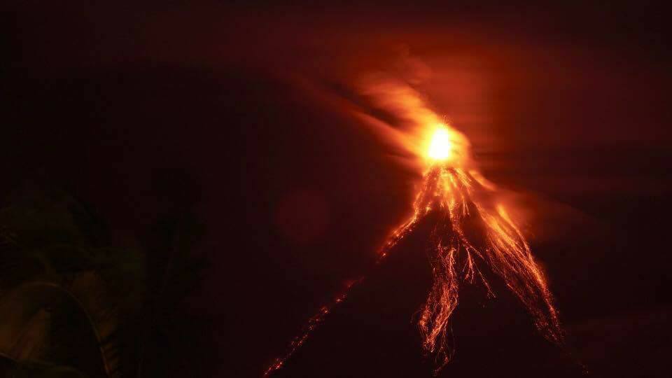
Mayon , Philippines :
MAYON VOLCANO BULLETIN , 18 January 2018 8:00 A.M.
Quiet lava effusion from the new summit lava dome and lava collapse events characterized Mayon Volcano’s eruptive activity in the past 24 hours. Forty-eight (48) rockfall events, two (2) pyroclastic density currents or PDCs and one (1) volcanic earthquake were recorded by Mayon’s seismic monitoring network. Rockfall events were generated by the collapsing lava front and margins of the advancing lava flow on the Miisi Gully and by shedding from the summit dome onto the Matanag and Buyuan Gullies. Currently, the Miisi lava flow has advanced to approximately three (3) kilometers from the summit crater whilst PDCs were emplaced roughly within the same reaches on this drainage, all well within the Permanent Danger Zone (PDZ). Ash clouds were lofted from the rockfall and PDCs events as well as from the persistent disintegration of lava on the advancing front of the Miisi lava flow before drifting to the southwest. Sulfur dioxide gas emission was measured at an average of 1159 tonnes/day on January 17, 2018.
Alert Level 3 remains in effect over Mayon Volcano, which means that it is currently in a relatively high level of unrest as magma is at the crater and hazardous eruption is possible within weeks or even days. The public is strongly advised to be vigilant and desist from entering the six (6) kilometer-radius Permanent Danger Zone (PDZ) and the 7-km Extended Danger Zone (EDZ) on the southern flanks due to the danger of rockfalls, landslides and sudden explosions or dome collapse that may generate hazardous volcanic flows. Increased vigilance against pyroclastic density currents, lahars and sediment-laden streamflows along channels draining the edifice is also advised. Civil aviation authorities must also advise pilots to avoid flying close to the volcano’s summit as ash from any sudden eruption can be hazardous to aircraft. Based on the seasonal wind pattern, ash fall events may most likely occur on the southwest side of the volcano.
DOST-PHIVOLCS maintains close monitoring of Mayon Volcano and any new development will be communicated to all concerned stakeholders.
Source : Phivolcs.
Photo : Rodrigo Contreras Lopez
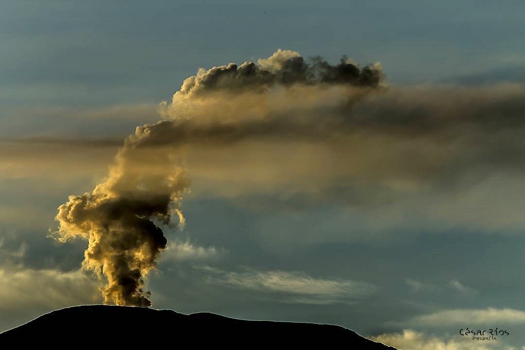
Nevado del Ruiz , Colombia :
Subject: Activity Bulletin of the Nevado del Ruiz Volcano.
The Activity Level continues in: Yellow Activity Level or (III): changes in the behavior of the volcanic activity.
With respect to the monitoring of the activity of the Nevado del Ruiz volcano, the COLOMBIAN GEOLOGICAL SERVICE informs that:
Over the course of the last week, the different monitoring parameters show that the Nevado del Ruiz volcano continues to exhibit unstable behavior.
The seismicity caused by the fracturing of the rocks that make up the volcano, showed a decrease in the number of earthquakes and in the seismic energy released, in comparison with the previous week. The earthquakes were located mainly in the sectors North distal, Suroccidente, Suroriente, Nororiente and in Arenas crater. The depths of the earthquakes ranged between 0.7 and 7.2 km. The maximum magnitude recorded during the week was 1.6 ML (Local Magnitude), corresponding to the earthquake recorded on January 9 at 22:09 (Local Time), located at the southwest of the Arenas crater, at a depth of 3.8 km.
The seismic activity associated with fluid dynamics inside the ducts of the volcanic structure showed an increase in the number of recorded earthquakes and in the seismic energy released, with respect to the previous week. This type of activity was characterized mainly by the occurrence of multiple fluid earthquakes, long period and very long period events, as well as tremor pulses. The earthquakes were located mainly in the vicinity of the Arenas crater and in the southeastern and southern sectors of the volcano. The recording of seismic signals of this type, of higher energy that may be associated with emission of gases and ash, is not ruled out.
The volcanic deformation measured from electronic inclinometers, GNSS stations (Global Navigation Satellite System) and radar images, show a stability behavior without registering important deformation processes of the volcanic structure.
The volcano continues to emit water vapor and gases into the atmosphere, among which sulfur dioxide (SO2) stands out, as evidenced by the values obtained by the SCANDOAS stations installed in the volcano area and the analysis of satellite images. In the follow-up of the information provided by the MIROVA and NASA FIRMS portals, several thermal anomalies were recorded in the vicinity of the Arenas crater.
The column of gases and steam reached a maximum height of 1300 m measured on the top of the volcano, on January 11. The direction of dispersion of the column was governed by the direction of the wind in the area, which during the week predominated towards the Northwest, Southwest and Southeast with respect to the Arenas crater.
The Nevado del Ruiz volcano continues at the Yellow activity level.
Source : SGC
Photo : Cesar Rios
Klyuchevskoy , Kamchatka :
VOLCANO OBSERVATORY NOTICE FOR AVIATION (VONA).
Issued: January 18 , 2018.
Volcano:Klyuchevskoy (CAVW #300260)
Current aviation colour code:ORANGE
Previous aviation colour code:orange
Source:KVERT
Notice Number:2018-20
Volcano Location:N 56 deg 3 min E 160 deg 38 min
Area:Kamchatka, Russia
Summit Elevation:15580 ft (4750 m)
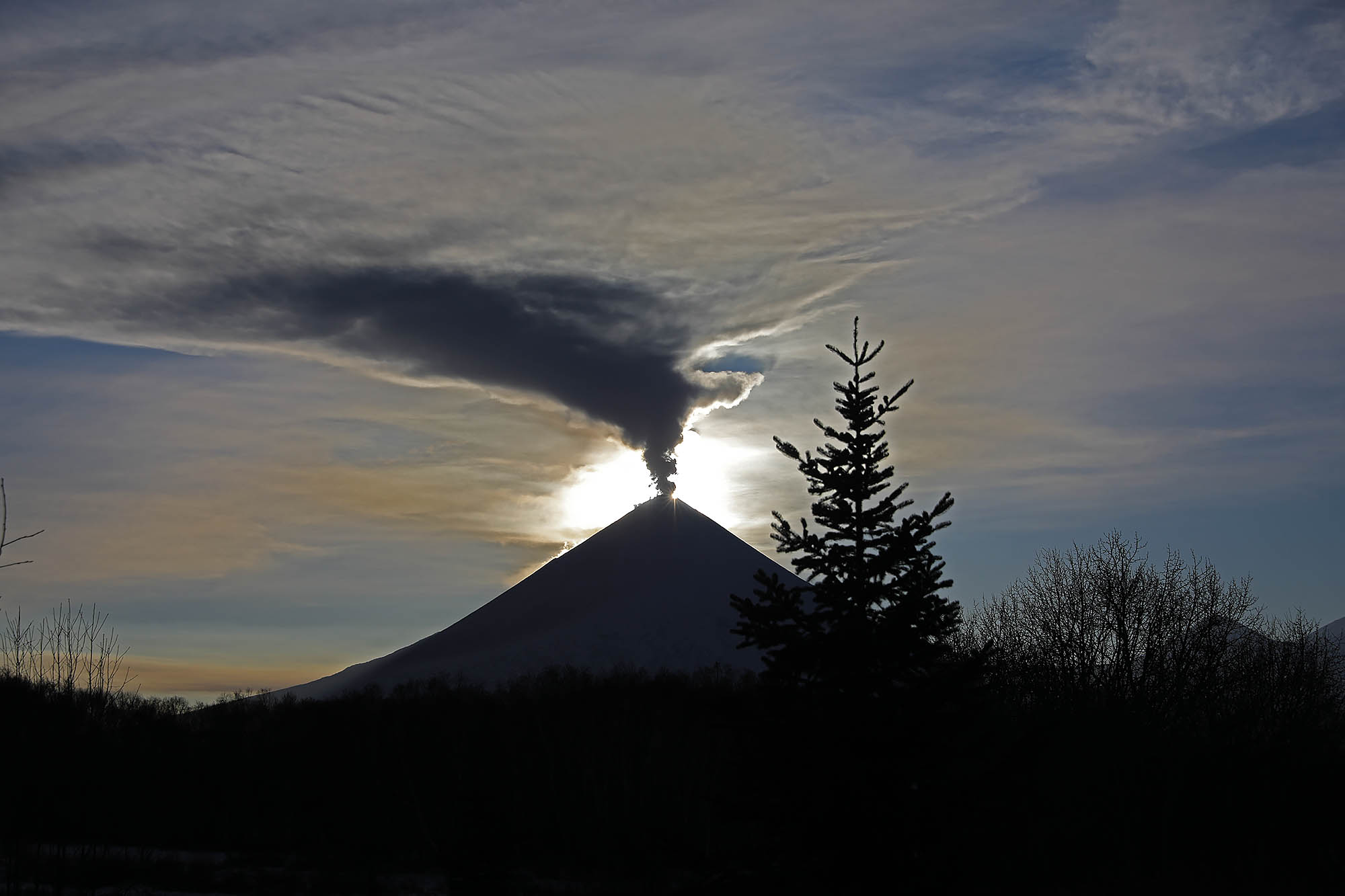
Volcanic Activity Summary:
The moderate eruptive activity of the volcano continues. A gas-steam plume containing some amount of ash drifted for about 45 km to the east from the volcano.
A moderate eruptive activity of the volcano continues. Ongoing activity could affect low-flying aircraft.
Volcanic cloud height:
16400 ft (5000 m) AMSL Time and method of ash plume/cloud height determination: 20180118/0500Z – Video data
Other volcanic cloud information:
Distance of ash plume/cloud of the volcano: 28 mi (45 km)
Direction of drift of ash plume/cloud of the volcano: E / azimuth 91 deg
Time and method of ash plume/cloud determination: 20180118/0440Z – Himawari-8
Source : Kvert.
Photo : Volkstat ru , Yu Demyanchuck.
Popocatépetl , Mexico :
January 17, 11:00 h (January 17, 17:00 GMT).
In the last 24 hours, through the seismic records of the Popocatépetl volcano monitoring system, 110 low intensity exhalations were identified, accompanied by water vapor, gas and sometimes very slight amounts of ash .
On the other hand, 26 minutes of harmonic tremor and 16 volcanotectonic earthquakes with magnitudes between M 1.2 and M2.2 were recorded.
During the night no incandescence was observed over the crater.

From today in the morning until the moment of this report the volcano is observed without emissions .
Other monitoring parameters remain unchanged.
CENAPRED urges NOT TO APPROACH the volcano and above all the crater, due to the danger of the fall of ballistic fragments , and in case of heavy rains, to get away from the bottoms of ravines due to the risk of landslides and mudflows.
The Popocatepetl Volcanic Alert Traffic Light is located in Amarillo Phase 2.
Source : Cenapred
Photo : Archive ( 02/2016)


No comment yet, add your voice below!