
January 17 , 2018.
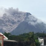
Mayon , Philippines :
MAYON VOLCANO BULLETIN 17 January 2018 8:00 A.M.
Lava effusion from the new summit lava dome and lava collapse events characterized Mayon Volcano’s eruptive activity in the past 24 hours. One hundred forty-three (143) lava collapse events and one (1) tremor were recorded by Mayon’s seismic monitoring network. The lava collapse events corresponded to rockfall along the front and margins of advancing lava and pyroclastic flows downriver of Miisi, Matanag, and Buyuan Gullies within the Permanent Danger Zone (PDZ). These events generated ash cloud that drifted towards the southwest. Sulfur dioxide gas emission was measured at an average of 3293 tonnes/day on January 16, 2018.
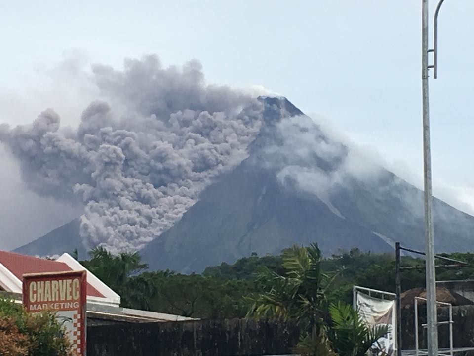
Alert Level 3 remains in effect over Mayon Volcano, which means that it is currently in a relatively high level of unrest as magma is at the crater and hazardous eruption is possible within weeks or even days. The public is strongly advised to be vigilant and desist from entering the six (6) kilometer-radius Permanent Danger Zone (PDZ) and the 7-km Extended Danger Zone (EDZ) on the southern flanks due to the danger of rockfalls, landslides and sudden explosions or dome collapse that may generate hazardous volcanic flows. Increased vigilance against pyroclastic density currents, lahars and sediment-laden streamflows along channels draining the edifice is also advised. Civil aviation authorities must also advise pilots to avoid flying close to the volcano’s summit as ash from any sudden eruption can be hazardous to aircraft. Based on the seasonal wind pattern, ash fall events may most likely occur on the southwest side of the volcano.
DOST-PHIVOLCS maintains close monitoring of Mayon Volcano and any new development will be communicated to all concerned stakeholders.
Source : Phivolcs
Photo : Al Francis Bichara
Cumbal , Colombia :
Subject: Cumbal Volcano Activity Bulletin.
The level of activity of the volcano is maintained at the level:
YELLOW LEVEL ■ (III): CHANGES IN THE CONDUCT OF VOLCANIC ACTIVITY.
Following the activity of the CUMBAL VOLCANIC COMPLEX, the COLOMBIAN GEOLOGICAL SERVICE informs that:
For the week between January 9 and January 15, 2018, seismic activity decreased slightly compared to the previous week, with the predominance of events associated with the movement of fluids inside the volcano. The rock fracturing events are located in the vicinity of the active La Plazuela cone, in the north-east of the volcanic complex, with depths of up to 6 km from the upper (4700 m) and maximum amplitude. local M1.0 on the Richter scale.
Favorable atmospheric conditions at the summit revealed gas emissions during all days of the evaluated period, mainly in the El Verde fumarole fields northeast of the volcanic complex; the emission columns were observed white, of low height and of directions of dispersion variable according to the direction of the wind.
The COLOMBIAN GEOLOGICAL SERVICE is attentive to the evolution of the volcanic phenomenon and will continue to inform in a timely manner of the detected changes.
Source : SGC
Kadovar , Papua New Guinea :
KADOVAR volcano in East Sepik has erupted and is acting in an unusual way, reports the volcanic observatory.
Nearby Biem volcano is inactive and Manam in Madang is normal as usual, says the Rabaul Volcanic Observatory (RVO).
The observatory’s principal geodetic surveyor, Steve Saunders said there are speculations of further volcanic activities along the Schouten Islands off the coast of East Sepik Province.
The Schouten Islands are a group of six small volcanic islands, including Bam, also known as Biem Island, Blup Blup or Rup Rup, Kadovar, Koil, Vokeo and Wei also known as Vial Island.
“Wei, Koil and Vokeo can be classed as extinct,” Mr Saunders said in a RVO update.
He confirmed Biem was inactive while Manam in Madang is displaying its normal almost sub-continuous activity as it has for years.
“There is no likelihood of related and regenerating volcanic activities from nearby volcanic islands since the eruption of Kadovar.
“We have confirmation from Biem that no volcanic activity has occurred.
“The volcanoes are fed by their own magma systems, which are not linked in any way.
“The eruption of one will not cause activity of another,” Mr Saunders said.
He said Manam was continuing its activity.
“It has displayed red glow and minor activity periodically for the last few years and there is no link to Kadovar.”
Source : RVO , Postcourrier . com .pg
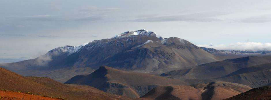
Ubinas , Peru :
Ubinas is the most active volcano in Peru. The last eruptive process began in September 2013 and presented its last explosion in January 2017. This process achieved a Volcanic Explosive Index (EVI) of 2, on a scale from 0 to 8.
Here is the summary of the activity between January 1st and 15th, 2018.
Analysis of the period:
The Ubinas volcano maintains low levels of activity. Registered seismicity is only related to rock fracturing or VTP type processes. During this period, we observed, on average, 1 event per day. The SO2 gas levels observed by the satellite are kept low.
During this period no seismic or fumarolic activity was recorded indicating changes in the current state of Ubinas.
Recommendations:
Before the start of the rainy season in the area, the probability of lahars occurring is latent, so stay away from the riverbeds and streams.
Implement prevention and mitigation measures in the face of increased activity.
Stay informed about the volcanic activity of Ubinas thanks to the reports published by the OVS-IGP.
The next report will be published on February 1st.
Source : IGP
Ticsani , Peru :
The Ticsani volcano is a stratovolcano whose main characteristic is to have presented very large avalanches. A possible eruption of this volcano is a potential danger for surrounding villages like Calacoa (8 km crater), Carumas (11 km) and others.
Here is the summary of the activity between January 1st and 15th, 2018.
Analysis of the period:
The Ticsani volcano has low levels of activity. The average seismic activity showed a rate of 20 events per day, which is considered low. A swarm of 6 VT type earthquakes, associated with rock fractures, was located 8 km east of the crater, spread between 5 km and 14 km deep. The SO2 gas levels observed by the satellite are kept low. Similarly, no thermal anomaly has been detected.
Recommendations:
Implement prevention and mitigation measures in the face of increased activity.
Stay informed about the volcanic activity of Ticsani through the reports published by the OVS-IGP.
The next report will be published on February 1st.
Source : IGP


No comment yet, add your voice below!