
January 09 , 2018.
Kadovar Island , Papua New Guinea :
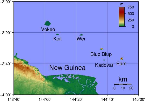
The Kadovar is located at the border of Madang and East Sepik and is one of the six islands in the SCHOUTEN group of islands. According to the Rabaul Volcanic Observatory, Kadovar Island volcano is likely to erupt and if it does, volcanoes on the nearby islands of Ruprup and Biem are also likely follow suit.
Due to the geographical isolation of the islands, evacuation is a difficulty but fortunately two ward councilors from Kadovar and the Ruprup islands took the initiative to organize the evacuation of 591 men, women and children of the Kadovar Island to the Ruprup Island.
All three Islands have an estimated population of 5000 plus but hopefully, the Authorities won’t need to evacuate all of them but the planning currently undertaken takes into account the worst case scenario. In the next few days the East Sepik Provincial Government and the National Disaster Office will be getting detail reports from all National Agencies concerned to access the current situation and deal with it in the most orderly and organized manner to assist the victims of this Natural Disaster currently faced.
The East Sepik Provincial Government is assuming the worst case scenario and planning and moving things as fast as they can. This includes a complete evacuation of the 5000 people if the 3 volcanic eruption does happen. As per the advice from the Rabaul Volcanic Observatory due to the shallowness of the area and the type of volcano Kadovar is, there is a chance of a Tsunami happening which could endanger the neighboring Islands and those along the Wewak coastline to as far as the mouth of the Sepik River including the Murik Lakes and villages along the Madang coast.
Authorities in Papua New Guinea have warned people living near the Kadovar Island volcano to prepare for the worst, with fears an eruption there could trigger a tsunami.
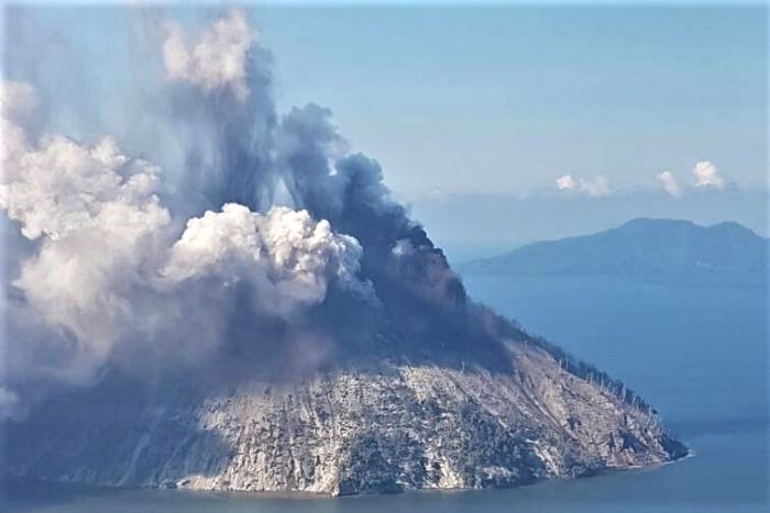
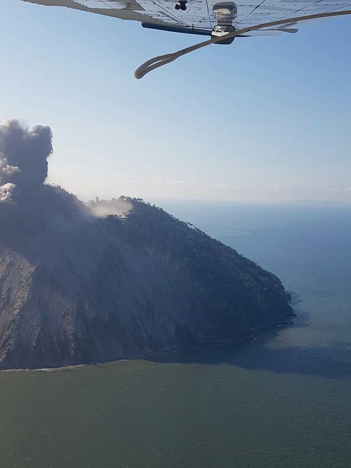
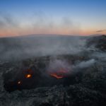
The long-dormant volcano rumbled to life late last week, sending ash into the sky and forcing around 700 people to evacuate to a neighbouring island.
Video taken during an aerial assessment of the island on Saturday showed a spectacular plume of smoke and ash billowing from its dome.
Ricky Wobar, the District Administrator for Wewak — the largest town on the mainland — was in the plane.
Mr Wobar said the nearly 700 people who live on the island took it upon themselves to evacuate, paddling to nearby Blup Blup island.

« If there was no initiative by boat, there would have been a very serious disaster, » he said.
« They also used small canoes that were heading towards Blup Blup.
There have been no recorded cases of eruptions of the Kadovar Island volcano in the recent past – however the historical records suggest that it could be one of the two « hot islands » mentioned by the explorer 17th century British Willliam Dampier.
There was an increase in thermal activity at the site in the late 1970s, and an increase in the frequency of earthquakes in mid-2015, but both eventually disappeared.
It was not listed as one of the 16 known active volcanoes in Papua New Guinea and was not monitored regularly.
Steve Saunders, senior geologist and acting director at the Rabaul Volcano Observatory, said the volcano was considered potentially active before the events of last week.
« Kadovar Island is very far away and the physical logistics or installation of equipment is very difficult.
Saunders said that because of the lack of equipment, it was difficult to predict what would happen next.
« Two things can happen: the rise of magma is likely to stop, and we hope the magma will cool down and things will return to normal, » he said.
« Or the magma will continue to rise to the surface … and because of the amount of time since the last eruption, the magma is probably rich in gas and the eruption will be very violent. »
For the moment scientists can only monitor the volcano from satellites or aerial flyovers, but Mr Saunders said authorities are trying to get the appropriate equipment to the island.
Matthew Moihoi, a seismologist at PNG’s Geophysical Observatory in Port Moresby, said any more serious activity could generate a tsunami.
« The base is somewhere underneath the ocean floor, and if there’s a chance the eruption might escalate then there might be a potential of a caldera collapse, » he said.
« And if that is the case then it will definitely generate a tsunami and then it will affect a wider community. »
« The magnitude of the tsunami would depend on how much material is moving into the water, » he said.
« So it could just be small landslides causing a ripple that you may see on the coast, or if a large chunk of the volcano falls off there would be a larger tsunami. »
Through provincial governments in PNG, Mr Saunders said the observatory is advising people to prepare for the possibility of a tsunami.
« We’ve basically got to prepare for the worst-case scenario, we can’t just say we hope it will just be small, » he said.
« We are just saying just prepare yourselves for the possibility of tsunami, and of course that’s a very difficult thing to say because we try not to panic people, but we want people to be ready in case there are some. »
Sources : news.pngfacts.com , abc.net.au.
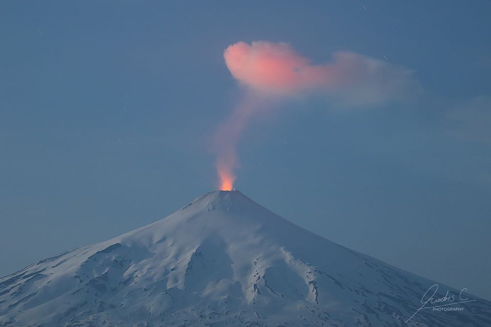
Villarica, Chile :
There were 4404 seismic events recorded, of which 4403 were classified as long-period type (LP) earthquakes, in relation to the fluid dynamics inside the volcano, with reduced displacement values of less than 16 cm2. In addition, 1 volcano-tectonic (VT) seismic event was recorded, associated with rock fracturing. The event had a local magnitude of M 1.3, and was located 3.8 km east of the active crater and at a depth of 4.9 km.
The series of volcanic tremor, seismic series also associated with the dynamics of the fluids inside the volcano during the period considered stabilized at an average value of 3 cm2. On the other hand, the dominant frequencies are maintained between 1.0 and 2.1 Hz.
The images recorded with the IP cameras installed near the volcano, when weather conditions permitted, had a less intense, low-rise, predominantly whitish degassing; this one did not exceed 300 m of height. In addition, nocturnal glow is recorded, sometimes associated with minor explosions at the crater level.
The infrasound sensor recorded 10 explosions associated with the surface activity of the lava lake housed in the main crater, with pressures greater than 1 pascal. The maximum value calculated was 2.7 pascals (average value considered).
According to data provided by five (5) GNSS stations and two (2) electronic inclinometers, no significant changes were detected due to changes in the internal activity of the volcano during the period.
The data obtained by the equipment of Optical Differential Absorption Spectroscopy (DOAS) stations at Los Nevados and Tralco, located respectively 10 km East-North-East (ENE) and 6 km East-South-East. (ESE) recorded an average value in sulfur dioxide (SO2) emission of 807 ± 370 t / day, with a maximum value of 1293 t / day, reported on 16 December. The parameters are in normal levels for volcano activity.
No emissions of sulfur dioxide (SO2) to the atmosphere in the volcano area have been reported, according to data published by the Ozone Monitoring Instrument (OMI) Sulfur Dioxide Group (http: / /so2.gsfc.nasa.gov/) and the National Environmental Satellite Information and Data Service (NESDIS) (http://satepsanoine.nesdis.noaa.gov).
During the period a decrease was reported in the number and intensity of thermal warnings on the volcano, with a maximum of volcanic radiative power (VRP) observed of 1MW on December 22, which is considered low, according to the data processed by Observation of volcanic activity (Mirova) (http://www.mirovaweb.it/).
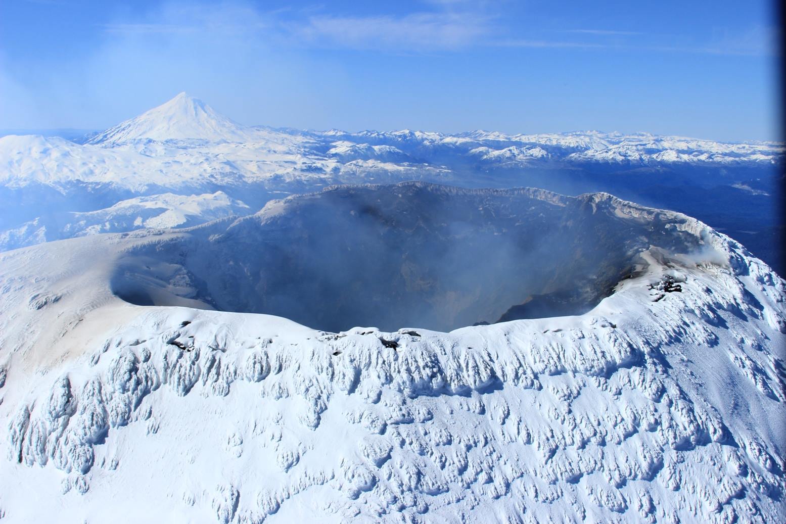
During this period, the monitoring parameters stabilized at a low level of activity, to reach a state of equilibrium, with the seismic production that characterizes this system and the surface activity associated with an open-duct volcano, with a persistent lava lake inside. Under these conditions, the risk of ejection of pyroclastic material in the vicinity of the crater persists.
As a result, the alert level is changed to:
GREEN LEVEL: Active volcano with stable behavior – No immediate risk – Time for possible eruption: MONTH / YEARS.
Observation: It is recommended to apply precautionary access restrictions to an area close to the crater with a radius of 500 m.
Source : Sernageomin
Sabancaya , Peru :
The explosive activity was maintained with a similar average the previous week, reaching 41 explosions a day. The predominance of earthquakes associated with the movement of fluids (long period type) continues, followed by events associated with ash emissions (Tremor). Lastly, the earthquakes associated with the rise of the magma (hybrid types) have increased slightly.

Eruptive columns of gases and ashes showed no greater variation than the previous week, reaching a maximum height of about 3000 m above the crater. The dispersal of these materials occurred within a radius of about 50 km, mainly to the west, northwest, and north.
The volcanic gas (SO2) flux recorded on January 5 has a maximum value of 3409 tonnes / day, a value considered large.
There were 9 thermal anomalies recorded according to the MIROVA system, with values between 2 MW and 33 MW VRP (Irradiated Volcano Power).
In general, eruptive activity maintains moderate levels. No major changes are expected in the following days.
Source : IGP
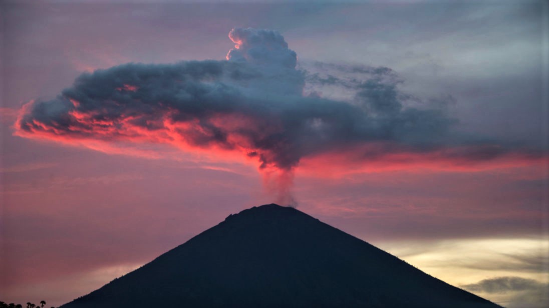
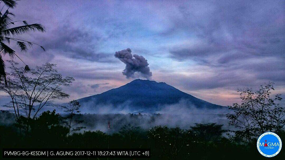
Agung , Indonesia :
On the basis of the results of the visual and instrumental data analysis and considering the potential threats of danger, on November 27, 2017 at 06:00, the status of G. Agung was raised from Level III (SIAGA) to Level IV (AWAS) . Since yesterday and until today visually the volcano is usually covered with fog. Gray, white, medium-pressure gray ash has a height of about 100 to 2000 mm above the summit and slopes to the south and southwest. At night, the glow of the incandescent lava is not observed.
Seismograph records dated 08 January 2018 noted:
3 shallow volcanic earthquakes (VB)
11 deep volcanic earthquakes (VA)
26 earthquakes emission.
No local tectonic earthquake (TL).
A continuous tremor with an amplitude of 1 to 8 mm and a dominant value of 1 mm.
As of January 9, 2018 (00:00 to 18:00) it has been registered:
4 emission earthquakes
2 shallow volcanic earthquakes (VB)
1 deep volcanic earthquakes (VA)
1 local tectonic earthquake (TL)
A continuous tremor with an amplitude of 1 to 2 mm and a dominant value of 1 mm.
Recommendations:
Communities around G. Agung and mountaineers / visitors / tourists must not climb, climb or do any activity in the danger zone around the G. Agung crater area and in all areas within 6 km from the crater of G. Agung. The estimated area risks are dynamic and continuously assessed and can be modified at any time based on the most recent observational data from G. Agung.
Level IV (AWAS) is only valid for a 6 km radius as mentioned above. Outside the activity area, everything can work like NORMAL and always SAFE.
VOLCANO OBSERVATORY NOTICE FOR AVIATION – VONA.
Issued: January 08 , 2018.
Volcano: Agung (264020)
Current Aviation Colour Code: ORANGE
Previous Aviation Colour Code: orange
Source: Agung Volcano Observatory
Notice Number: 2018AGU04
Volcano Location: S 08 deg 20 min 31 sec E 115 deg 30 min 29 sec
Area: Bali, Indonesia
Summit Elevation: 10054 FT (3142 M)
Volcanic Activity Summary:
Eruption with volcanic ash cloud at 14h22 UTC ( 22h22 local). Eruption and ash emission is not continuing
Volcanic Cloud Height:
Best estimate of ash-cloud top is around 16454 FT (5142 M) above sea level, may be higher than what can be observed clearly. Source of height data: ground observer.
Other Volcanic Cloud Information:
Ash-cloud moving to southeast and east
Remarks:
Seismic activity is characterized by low Frequency earthquakes and tremor
Source : VSI , Magma.
Photos : Skynews ( 01/12/2017), Magma ( 11/12/2017)


No comment yet, add your voice below!